File:Empress of Ireland wreck position.png
No higher resolution available.
Empress_of_Ireland_wreck_position.png (698 × 480 pixels, file size: 576 KB, MIME type: image/png)
Captions
Captions
Add a one-line explanation of what this file represents
Summary edit
| Description |
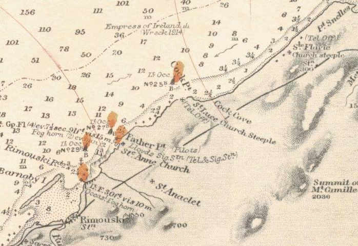
English: Part of nautical chart showing the position of the wreck Empress of Ireland.
Near Pointe au Père (Father point). |
| Source |
Site [1] Cart Nbr: 307 . Canada RIVER ST LAWRENCE WEST PT OF ANTICOSTI TO SAGUENAY RIVER |
| Author | user:Clipper |
Licensing edit
This image is in the public domain because it contains materials that originally came from the U.S. National Oceanic and Atmospheric Administration, taken or made as part of an employee's official duties.
|
File history
Click on a date/time to view the file as it appeared at that time.
| Date/Time | Thumbnail | Dimensions | User | Comment | |
|---|---|---|---|---|---|
| current | 14:32, 8 June 2007 | | 698 × 480 (576 KB) | Clipper (talk | contribs) | Part of nautical chart showing the position of the wreck ''Empress of Ireland''. Near Pointe Saint Père (Father point). Near Rimouski. category:nautical chart |
You cannot overwrite this file.
File usage on Commons
There are no pages that use this file.
File usage on other wikis
The following other wikis use this file:
- Usage on de.wikipedia.org
- Usage on en.wikipedia.org
- Usage on fr.wikipedia.org
- Usage on sv.wikipedia.org