File:Energie-public-600b.png
Size of this preview: 471 × 599 pixels. Other resolutions: 189 × 240 pixels | 600 × 763 pixels.
Original file (600 × 763 pixels, file size: 197 KB, MIME type: image/png)
Captions
Captions
Add a one-line explanation of what this file represents
Summary edit
| Description | |
| Date | |
| Source |
Nederlands: self made door Jan-Willem van Aalst:
|
| Author | Janwillemvanaalst |
| Permission (Reusing this file) |
CC NL 2.5 |
| Other versions |
|


Licensing edit
I, the copyright holder of this work, hereby publish it under the following license:
This file is licensed under the Creative Commons Attribution-Share Alike 3.0 Unported license.
- You are free:
- to share – to copy, distribute and transmit the work
- to remix – to adapt the work
- Under the following conditions:
- attribution – You must give appropriate credit, provide a link to the license, and indicate if changes were made. You may do so in any reasonable manner, but not in any way that suggests the licensor endorses you or your use.
- share alike – If you remix, transform, or build upon the material, you must distribute your contributions under the same or compatible license as the original.
File history
Click on a date/time to view the file as it appeared at that time.
| Date/Time | Thumbnail | Dimensions | User | Comment | |
|---|---|---|---|---|---|
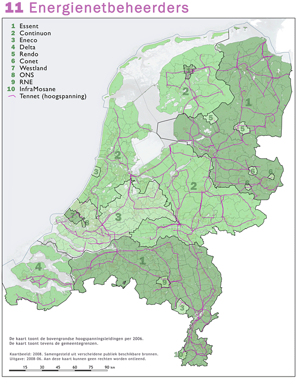
| current | 19:44, 21 May 2008 | | 600 × 763 (197 KB) | Janwillemvanaalst (talk | contribs) | {{Information |Description=Energienetbeheerders |Source=self-made door Jan-Willem van Aalst: * Referentie-ondergrond (kustlijn, steden, wegen) gerasterd uit de OpenStreet Map OSM. (http://www.openstreetmap.org/index.html) Inhoud is beschikbaar onder de Cr |
You cannot overwrite this file.
File usage on Commons
The following page uses this file:
File usage on other wikis
The following other wikis use this file:
- Usage on fa.wikipedia.org
- Usage on nl.wikipedia.org
- Usage on no.wikipedia.org