File:Energieatlas Bayern Karte Wind.jpg

Size of this preview: 800 × 448 pixels. Other resolutions: 320 × 179 pixels | 640 × 358 pixels | 1,024 × 573 pixels | 1,680 × 940 pixels.
Original file (1,680 × 940 pixels, file size: 971 KB, MIME type: image/jpeg)
Captions
Captions
Add a one-line explanation of what this file represents
Summary edit
| Description |
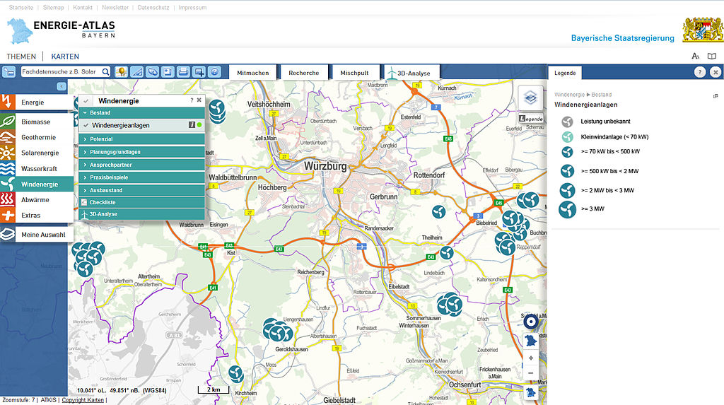
Deutsch: Kartenausschnitt Würzburg des Energie-Atlas Bayern (http://www.energieatlas.bayern.de/) mit aktivierter Datenebene Windenergieanlagen |
| Date | |
| Source | http://geoportal.bayern.de/energieatlas-karten/?lon=4349440.5&lat=5514176.0&zoom=7&base=910&layers=905(1.0)^16(1.0) |
| Author | Bayerisches Landesamt für Umwelt, Energie-Atlas Bayern, Ruven Nagel (Diskussion) |
| Permission (Reusing this file) |
Licensing edit
This file is licensed under the Creative Commons Attribution-Share Alike 3.0 Germany license.
- You are free:
- to share – to copy, distribute and transmit the work
- to remix – to adapt the work
- Under the following conditions:
- attribution – You must give appropriate credit, provide a link to the license, and indicate if changes were made. You may do so in any reasonable manner, but not in any way that suggests the licensor endorses you or your use.
- share alike – If you remix, transform, or build upon the material, you must distribute your contributions under the same or compatible license as the original.

Original upload log edit
Transferred from de.wikipedia to Commons by Wdwdbot using script bot_filetrans.pl.
The original description page was here. All following user names refer to de.wikipedia.
- 2014-08-20 15:11:47 Harzerkatze (422507 Bytes) aktuelles Layout
- 2014-08-20 13:12:34 Harzerkatze (399473 Bytes) {{Information |Beschreibung = Kartenausschnitt Würzburg des Energie-Atlas Bayern (http://www.energieatlas.bayern.de/) mit aktivierter Datenebene Windenergieanlagen |Quelle = http://www.energieatlas.bayern.de, Screenshot |Urheber…
File history
Click on a date/time to view the file as it appeared at that time.
| Date/Time | Thumbnail | Dimensions | User | Comment | |
|---|---|---|---|---|---|
| current | 12:18, 11 November 2014 | | 1,680 × 940 (971 KB) | Harzerkatze (talk | contribs) | The Website has changed its colors and layout, the screenshot shows the new version. As before, the screenshot shows the maps of Würzburg in the Energie-Atlas Bayern, with the wind turbines layer and legend activated. Link: http://geoportal.bayern.de/... |
| 22:01, 5 September 2014 |  | 1,680 × 925 (413 KB) | Wdwdbot (talk | contribs) | Bot Move: Original uploader of this revision (#2) was Harzerkatze at de.wikipedia | |
| 22:01, 5 September 2014 |  | 1,680 × 923 (390 KB) | Wdwdbot (talk | contribs) | Bot Move: Original uploader of this revision (#1) was Harzerkatze at de.wikipedia |
You cannot overwrite this file.
File usage on Commons
There are no pages that use this file.