File:English administrative divisions 2010.svg

Size of this PNG preview of this SVG file: 494 × 600 pixels. Other resolutions: 198 × 240 pixels | 395 × 480 pixels | 633 × 768 pixels | 843 × 1,024 pixels | 1,687 × 2,048 pixels | 1,108 × 1,345 pixels.
Original file (SVG file, nominally 1,108 × 1,345 pixels, file size: 366 KB)
Captions
Captions
Add a one-line explanation of what this file represents
Summary edit
| Description |
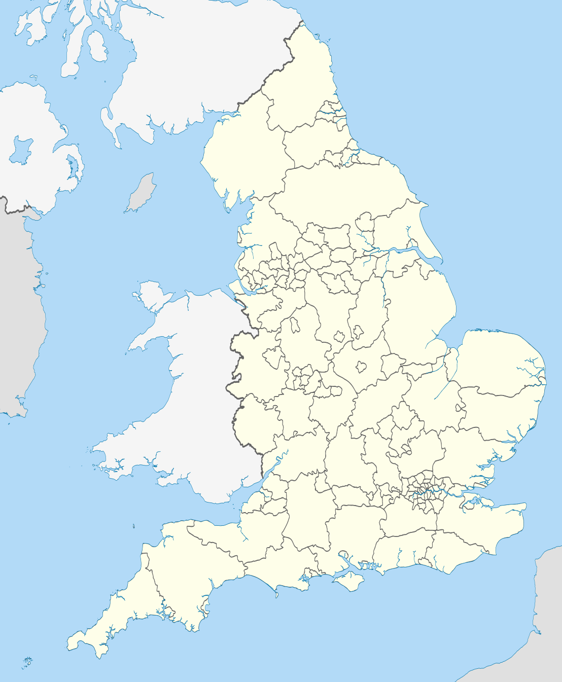
Map showing the all top-tier administrative subdivisions of England (shire counties, metropolitan counties, London boroughs and Unitary Authorities) in 2010 Equirectangular map projection on WGS 84 datum, with N/S stretched 170% Geographic limits:
|
| Date | |
| Source |
National Geospatial-Intelligence Agency
|
| Author | Nilfanion |
| Other versions |
Derivative works of this file: |
Licensing edit
I, the copyright holder of this work, hereby publish it under the following licenses:
This file is licensed under the Creative Commons Attribution-Share Alike 3.0 Unported license.
- You are free:
- to share – to copy, distribute and transmit the work
- to remix – to adapt the work
- Under the following conditions:
- attribution – You must give appropriate credit, provide a link to the license, and indicate if changes were made. You may do so in any reasonable manner, but not in any way that suggests the licensor endorses you or your use.
- share alike – If you remix, transform, or build upon the material, you must distribute your contributions under the same or compatible license as the original.

|
Permission is granted to copy, distribute and/or modify this document under the terms of the GNU Free Documentation License, Version 1.2 or any later version published by the Free Software Foundation; with no Invariant Sections, no Front-Cover Texts, and no Back-Cover Texts. A copy of the license is included in the section entitled GNU Free Documentation License. |
You may select the license of your choice.
File history
Click on a date/time to view the file as it appeared at that time.
| Date/Time | Thumbnail | Dimensions | User | Comment | |
|---|---|---|---|---|---|
| current | 22:02, 23 November 2010 | | 1,108 × 1,345 (366 KB) | Nilfanion (talk | contribs) | England only |
| 22:00, 23 November 2010 |  | 1,108 × 1,345 (401 KB) | Nilfanion (talk | contribs) | {{Information |Description=Map showing the all top-tier administrative subdivisions of England (shire counties, metropolitan counties, London boroughs and Unitary Authorities) in 2010 Equirectangular map projection on WGS 84 datum, with N/S stretched 170 |
You cannot overwrite this file.
File usage on Commons
More than 100 pages use this file. The following list shows the first 100 pages that use this file only. A full list is available.
- User:Nilfanion/Maps/National
- File:Barking and Dagenham in England (zoom).svg
- File:Barnet in England (zoom).svg
- File:Barnsley in England.svg
- File:Barnsley in England (special marker).svg
- File:Bexley in England (zoom).svg
- File:Birmingham in England.svg
- File:Birmingham in England (special marker).svg
- File:Bolton in England.svg
- File:Bolton in England (special marker).svg
- File:Bradford in England.svg
- File:Bradford in England (special marker).svg
- File:Brent in England (zoom).svg
- File:Bromley in England (zoom).svg
- File:Bury in England.svg
- File:Bury in England (special marker).svg
- File:Calderdale in England.svg
- File:Calderdale in England (special marker).svg
- File:Camden in England (zoom).svg
- File:City of Westminster in England (zoom).svg
- File:Coventry in England.svg
- File:Coventry in England (special marker).svg
- File:Croydon in England (zoom).svg
- File:Doncaster in England.svg
- File:Doncaster in England (special marker).svg
- File:Dudley in England.svg
- File:Dudley in England (special marker).svg
- File:Ealing in England (zoom).svg
- File:Enfield in England (zoom).svg
- File:Gateshead in England.svg
- File:Gateshead in England (special marker).svg
- File:Greenwich in England (zoom).svg
- File:Hackney in England (zoom).svg
- File:Hammersmith and Fulham in England (zoom).svg
- File:Haringey in England (zoom).svg
- File:Harrow in England (zoom).svg
- File:Havering in England (zoom).svg
- File:Hillingdon in England (zoom).svg
- File:Hounslow in England (zoom).svg
- File:Islington in England (zoom).svg
- File:Kensington and Chelsea in England (zoom).svg
- File:Kingston upon Thames in England (zoom).svg
- File:Kirklees in England.svg
- File:Kirklees in England (special marker).svg
- File:Knowsley in England.svg
- File:Knowsley in England (special marker).svg
- File:Lambeth in England (zoom).svg
- File:Leeds in England.svg
- File:Leeds in England (special marker).svg
- File:Lewisham in England (zoom).svg
- File:Liverpool in England.svg
- File:Liverpool in England (special marker).svg
- File:Manchester in England.svg
- File:Manchester in England (special marker).svg
- File:Merton in England (zoom).svg
- File:Newcastle upon Tyne in England.svg
- File:Newcastle upon Tyne in England (special marker).svg
- File:Newham in England (zoom).svg
- File:North Tyneside in England.svg
- File:North Tyneside in England (special marker).svg
- File:Oldham in England.svg
- File:Oldham in England (special marker).svg
- File:Redbridge in England (zoom).svg
- File:Richmond upon Thames in England (zoom).svg
- File:Rochdale in England.svg
- File:Rochdale in England (special marker).svg
- File:Rotherham in England.svg
- File:Rotherham in England (special marker).svg
- File:Salford in England.svg
- File:Salford in England (special marker).svg
- File:Sandwell in England.svg
- File:Sandwell in England (special marker).svg
- File:Sefton in England.svg
- File:Sefton in England (special marker).svg
- File:Sheffield in England.svg
- File:Sheffield in England (special marker).svg
- File:Solihull in England.svg
- File:Solihull in England (special marker).svg
- File:South Tyneside in England.svg
- File:South Tyneside in England (special marker).svg
- File:Southwark in England (zoom).svg
- File:St Helens in England.svg
- File:St Helens in England (special marker).svg
- File:Stockport in England.svg
- File:Stockport in England (special marker).svg
- File:Sunderland in England.svg
- File:Sunderland in England (special marker).svg
- File:Sutton in England (zoom).svg
- File:Tameside in England.svg
- File:Tameside in England (special marker).svg
- File:Tower Hamlets in England (zoom).svg
- File:Trafford in England.svg
- File:Trafford in England (special marker).svg
- File:Wakefield in England.svg
- File:Wakefield in England (special marker).svg
- File:Walsall in England.svg
- File:Walsall in England (special marker).svg
- File:Waltham Forest in England (zoom).svg
- File:Wandsworth in England (zoom).svg
- File:Wigan in England.svg
.svg)
.svg)
.svg)
.svg)
.svg)
.svg)
.svg)
.svg)
.svg)
.svg)
.svg)
.svg)
.svg)
.svg)
.svg)
.svg)
.svg)
.svg)
.svg)
.svg)
.svg)
.svg)
.svg)
.svg)
.svg)
.svg)
.svg)
.svg)
.svg)
.svg)
.svg)
.svg)
.svg)
.svg)
.svg)
.svg)
.svg)
.svg)
.svg)
.svg)
.svg)
.svg)
.svg)
.svg)
.svg)
.svg)
.svg)
.svg)
.svg)
.svg)
.svg)
.svg)
.svg)
.svg)
.svg)
.svg)
.svg)
.svg)
.svg)
.svg)
.svg)
.svg)
.svg)
.svg)
.svg)
View more links to this file.