File:Entebbe- Uganda, Africa 1- 250,000 WDL9942.png

Size of this preview: 466 × 600 pixels. Other resolutions: 186 × 240 pixels | 373 × 480 pixels | 597 × 768 pixels | 1,024 × 1,318 pixels.
Original file (1,024 × 1,318 pixels, file size: 2.79 MB, MIME type: image/png)
Captions
Captions
Add a one-line explanation of what this file represents
Summary edit
| Author |
Русский: Топографическая съемка Уганды
Français : Service d'études topographiques de l'Ouganda
English: Uganda Topographical Survey
中文:乌干达地形测量部
Português: Levantamento Topográfico de Uganda
العربية: قسم المسح الطوبوغرافي بأوغندا
Español: Estudio topográfico de Uganda |
| Title |
Русский: Энтеббе: Уганда, Африка 1: 250 000
Français : Entebbe : Ouganda, Afrique 1 : 250 000
English: Entebbe: Uganda, Africa 1: 250,000
中文:恩德培,乌干达,非洲 1:250,000
Português: Entebbe: Uganda, África 1: 250,000
العربية: عِنتيبي: أوغندا، إفريقيا 1: 250.000
Español: Entebbe: Uganda, África 1: 250 000 |
| Description |
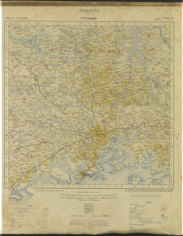
Русский: На этой карте 1911 г. изображен город Энтеббе — местонахождение правительства протектората Уганды до обретения страной независимости в 1962 г. Она основана на геофизических исследованиях, проводимых Топографической съемкой Уганды в 1909—1910 гг. и Топографическим управлением Уганды в 1907—1908 гг., закончена Географическим отделом Генерального штаба и отпечатана в Военном министерстве в Лондоне. На карте изображены округа, королевства, водные источники и большие города вокруг Энтеббе, а также телеграфные линии и станции, железные дороги, почтовые отделения и протестантские и католические миссии. Показано пять категорий дорог, начиная с "дорог с твердым покрытием 1-го класса" и заканчивая "второстепенными дорогами в отдаленных районах". В примечании сказано: "Страна, в основном, покрыта негустым, разбросанным по всей территории кустарником. Для придания четкости показаны только леса и густой кустарник". Энтеббе расположен на северном берегу озера Виктория — самого большого озера в Африке — примерно в 37 километрах к юго-западу от Кампалы, столицы Уганды. Здесь расположен международный аэропорт Энтеббе — самый большой в Уганде коммерческий и военный аэропорт, получивший известность в 1976 г. во время сенсационного спасения более 100 граждан Израиля, находившихся в заложниках на угнанном французском пассажирском самолете, захваченном арабскими и немецкими террористами.
Протектораты; Виктория, озеро Français : Cette carte de 1911 illustre Entebbe, qui fut le siège du gouvernement du protectorat de l'Ouganda avant son indépendance en 1962. Réalisée à partir des études du Service d'études topographiques de l'Ouganda entre 1909 et 1910, et du Département topographique de l'Ouganda entre 1907 et 1908, elle fut terminée par le service de géographie de l'état-major général et imprimée au ministère de la Guerre à Londres. Elle illustre les pays, les royaumes, les sources d'eau et les villes majeures d'Entebbe et de ses alentours, ainsi que les stations et lignes télégraphiques, les chemins de fer, les bureaux de poste, et les missions protestantes et catholiques. Cinq types de route sont indiqués, des « routes asphaltées de première classe » aux « sentiers ruraux secondaires ». Une note indique : « De façon générale, le pays est couvert d'une brousse fine disséminée. Par souci de clarté, seules les forêts et brousses très denses sont représentées ». La ville d'Entebbe est située sur la rive nord du lac Victoria, le plus grand lac d'Afrique, à environ 37 kilomètres au sud-ouest de Kampala, capitale de l'Ouganda. Elle est connue pour son aéroport international, l'aéroport commercial et militaire le plus important de l'Ouganda, et le sauvetage dramatique en 1976 de plus de 100 citoyens israéliens retenus en otage sur un avion de ligne français détourné par des terroristes arabes et allemands.
Protectorats; Lac Victoria English: This 1911 map shows Entebbe, the seat of government of the Protectorate of Uganda prior to independence in 1962. It is based on surveys by the Uganda Topographical Survey of 1909–10 and the Uganda Survey Department of 1907–8, completed by the Geographical Section of the General Staff, and printed at the War Office in London. Depicted are the counties, kingdoms, water springs, and major towns within and around Entebbe, along with telegraph lines and stations, railways, post offices, and Protestant and Catholic mission stations. Five categories of roads are shown, from “1st class, metalled roads” to “minor bush tracks.” A note indicates: “The Country generally is covered with thin scattered bush. For the sake of clearness, only forest and thick bush are shown.” Entebbe is located on the northern shore of Lake Victoria, Africa’s largest lake, approximately 37 kilometers southwest of Kampala, the capital of Uganda. It is the location of Entebbe International Airport, Uganda's largest commercial and military airport, best known for the dramatic rescue in 1976 of more than 100 Israeli citizens held hostage on a hijacked French airliner by Arab and German terrorists.
Protectorates; Victoria, Lake 中文:这幅作于 1911 年的地图描绘的是 1962 年在乌干达保护国独立前,其政府的所在地恩德培。该地图以乌干达地形测量部1909-10 年间以及乌干达测绘部 1907-8 年间的勘测结果为基础,由总参谋部地理处绘制,刊印于伦敦陆军部。地图中描绘了恩德培市内及周边地区的县、王国、泉水、主要城镇,以及电报线路、车站、邮局、新教和天主教传教站。图中显示了从“碎石铺成的阳关道”到“灌木丛小径”的五种类型的道路。一则注解指出:“乡村基本上被稀疏分散的灌木丛覆盖。为清楚展示地形,只显示出了森林和茂密的灌木丛”。恩德培坐落在非洲最大湖维多利亚湖的北岸,位于乌干达首都坎帕拉西南约 37 公里处。这里是乌干达最大的商业和军事机场——恩德培国际机场——的所在地。1976 年,法航班机中被阿拉伯和德国恐怖分子劫为人质的 100 多名以色列公民在这里戏剧般获救,该机场因此闻名。
保护国; 维多利亚湖 Português: Este mapa de 1911 mostra Entebbe, a sede do governo do Protetorado de Uganda antes da independência em 1962. Ele se baseia em pesquisas do Levantamento Topográfico de Uganda de 1909-1910 e do Departamento de Pesquisa de Uganda de 1907-1908, concluídos pela Seção Geográfica da Equipe Geral, e impressos no Departamento de Guerra, em Londres. Estão representados os condados, reinos, nascentes de água e as principais vilas, dentro e ao redor de Entebbe, juntamente com as linhas telegráficas e estações, ferrovias, correios e estações missionárias protestantes e católicas. São mostradas cinco categorias de estradas, desde "estradas pavimentadas de 1ª classe" até "trilhas inferiores com vegetação". Uma nota indica: "O país é normalmente coberto por uma vegetação fina e dispersa. Por uma questão de visibilidade, apenas floresta e vegetação mais espessa são mostradas." Entebbe localiza-se na costa norte do Lago Vitória, o maior da África, a aproximadamente 37 quilômetros ao sudoeste de Kampala, a capital de Uganda. É a localização do Aeroporto Internacional de Entebbe, o maior aeroporto comercial e militar de Uganda, mais conhecido pelo dramático resgate, em 1976, de mais de 100 cidadãos israelenses mantidos reféns em um avião de uma companhia francesa sequestrado por terroristas árabes e alemães.
Protetorados; Lago Vitória العربية: تُظهِر هذه الخريطة، التي ترجع إلى العام 1911، مدينة عِنتيبي، مقر حكومة محمية أوغندا قبل الاستقلال في عام 1962. تستند الخريطة إلى عمليات مسح أجراها قسم المسح الطوبوغرافي بأوغندا في 1909–1910 وقسم عمليات المسح بأوغندا في 1907–1908. وقد أكملتْ الخريطةَ الشعبةُ الجغرافية التابعة لهيئة الأركان العامة، وطُبِعَت في وزارة الحربية في لندن. تُصور الخريطة المقاطعات والممالك وينابيع المياه والمدن الكبرى داخل عِنتيبي وحولها، بالإضافة إلى خطوط ومحطات التلغراف والسكك الحديدية ومكاتب البريد ومراكز التبشير البروتستانتية والكاثوليكية. وتظهر خمس فئات من الطرق، بدءاً من "طرق الدرجة الأولى المعدنية" وحتى "المسارات الصغيرة المُغطاة بالأجمات." هناك ملاحظة تقول: "البلاد مُغطاة بشكل عام بغطاء من الأجمات القليلة المتناثرة. لا تظهر في الخريطة إلا الغابات والأجمات الكثيفة، وذلك بغرض الوضوح." تقع عِنتيبي على الضفة الشمالية لبحيرة فيكتوريا، وهي أكبر البحيرات الإفريقية، على مسافة 37 كيلو متر تقريباً غرب كمبالا، عاصمة أوغندا. وهي مقر مطار عِنتيبي الدولي، أكبر مطار تجاري وعسكري بأوغندا، والذي اشتهر بعملية الإنقاذ المثيرة التي تمت في عام 1976 لتحرير أكثر من 100 مواطن إسرائيلي اُحتجِزوا كرهائن على يد مجموعة إرهابية من العرب والألمان على متن طائرة ركاب فرنسية مُختَطَفة.
المحميات; بحيرة فيكتوريا Español: Este mapa de 1911 muestra Entebbe, la sede del gobierno del Protectorado de Uganda antes de la independencia en 1962. Se basa en estudios realizados para el Estudio topográfico de Uganda de 1909-1910 y el Departamento de Estudios de Uganda en 1907-1908, completado por la Sección Geográfica del Estado Mayor General e impreso en la Oficina de Guerra en Londres. Están representadas las provincias, los reinos, los manantiales de agua y las principales ciudades dentro y alrededor de Entebbe, junto con las líneas y estaciones telegráficas, vías férreas, oficinas de correos y estaciones misioneras protestantes y católicas. Se muestran cinco categorías de carreteras, desde las «de primera clase, asfaltadas» hasta los «pasos de monte menores». Una nota dice: «En general, el país está cubierto de finos arbustos dispersos. Para mayor claridad, solo se muestran la selva y los matorrales espesos». Entebbe está situado en la orilla norte del lago Victoria, el lago más grande de África, aproximadamente a 37 kilómetros al sudoeste de Kampala, la capital de Uganda. La ubicación del aeropuerto internacional de Entebbe, el mayor aeropuerto comercial y militar de Uganda, es más conocida por el dramático rescate, en 1976, de más de 100 ciudadanos israelíes tomados como rehenes en un avión francés secuestrado por terroristas árabes y alemanes.
Protectorados; Victoria, lago |
| Date | 1911 |
| Medium |
Русский: Карты
Français : Cartes
English: Maps
中文:地图
Português: Mapas
العربية: خرائط
Español: Mapas |
| Dimensions |
English: 1 folded map, 65 x 59 centimeters |
| Collection |
Русский: Национальная библиотека Уганды
Français : Bibliothèque nationale d'Ouganda
English: National Library of Uganda
中文:乌干达国家图书馆
Português: Biblioteca Nacional de Uganda
العربية: مكتبة يوغندا الوطنية
Español: Biblioteca Nacional de Uganda |
| Place of creation |
Русский: Энтеббе
Français : Entebbe
English: Entebbe
中文:恩德培
Português: Entebbe
العربية: عنتيبي
Español: Entebbe |
| Notes |
Русский: Из Национального института Уганды по изучению рыбных ресурсов. Оцифровано в Национальной библиотеке Уганды при поддержке Корпорации Карнеги в Нью-Йорке.
Français : Source provenant de l'Institut national de recherche sur les ressources halieutiques ougandais. Numérisé à la Bibliothèque nationale d'Ouganda avec la collaboration de la Carnegie Corporation de New York.
English: From the Uganda National Fisheries Resources Research Institute. Digitized at the National Library of Uganda with support from the Carnegie Corporation of New York.
中文:出自乌干达国家渔业资源研究院。在纽约卡耐基基金会的支持下,在乌干达国家图书馆数字化。
Português: Do Instituto Nacional de Pesquisa de Recursos de Pesca de Uganda. Digitalizado na Biblioteca Nacional de Uganda, com o apoio da Corporação Carnegie, de Nova Iorque.
العربية: من معهد أوغندا القومي لأبحاث مصادر الثروة السمكية. تمت الرقمنة في المكتبة الوطنية بأوغندا بدعم من مؤسسة كارنيغي بنيويورك.
Español: Perteneciente al Instituto de Investigación Nacional de Recursos Pesqueros de Uganda. La digitalización se realizó en la Biblioteca Nacional de Uganda, con el apoyo de la Corporación Carnegie de Nueva York. |
| Source/Photographer |
|
Licensing edit
|
This is a faithful photographic reproduction of a two-dimensional, public domain work of art. The work of art itself is in the public domain for the following reason:
The official position taken by the Wikimedia Foundation is that "faithful reproductions of two-dimensional public domain works of art are public domain".
This photographic reproduction is therefore also considered to be in the public domain in the United States. In other jurisdictions, re-use of this content may be restricted; see Reuse of PD-Art photographs for details. | ||||
File history
Click on a date/time to view the file as it appeared at that time.
| Date/Time | Thumbnail | Dimensions | User | Comment | |
|---|---|---|---|---|---|
| current | 05:48, 12 March 2014 | | 1,024 × 1,318 (2.79 MB) | Fæ (talk | contribs) | =={{int:filedesc}}== {{Artwork |artist = |author ={{ru|1=Топографическая съемка Уганды}} {{fr|1=Service d'études topographiques de l'Ouganda}} {{en|1=Uganda Topographical Survey}} {{zh|1=乌干达地形测量部}} {{... |
You cannot overwrite this file.
File usage on Commons
The following page uses this file: