File:Eppington and surrounding plantations and traffic routes on Chesterfield 1888 Map.jpg

Size of this preview: 493 × 599 pixels. Other resolutions: 197 × 240 pixels | 395 × 480 pixels | 632 × 768 pixels | 1,090 × 1,325 pixels.
Original file (1,090 × 1,325 pixels, file size: 310 KB, MIME type: image/jpeg)
Captions
Captions
Add a one-line explanation of what this file represents
Summary edit
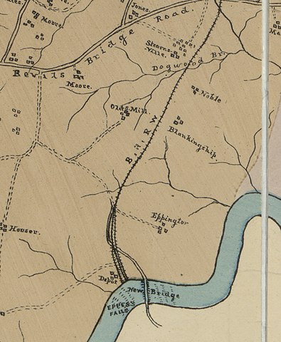
| Description |
English: Map of Chesterfield County, Virginia 1888, cropped to show Eppington Plantation and the surrounding areas. |
||
| Date | |||
| Source |
|
||
| Author | LaPrade, J. E. (Joseph Edgar), 1845-1903. |

| Camera location | | View this and other nearby images on: OpenStreetMap |
|---|
Licensing edit
This work is in the public domain in the United States because it was published (or registered with the U.S. Copyright Office) before January 1, 1929.
Public domain works must be out of copyright in both the United States and in the source country of the work in order to be hosted on the Commons. If the work is not a U.S. work, the file must have an additional copyright tag indicating the copyright status in the source country.
Note: This tag should not be used for sound recordings. |
File history
Click on a date/time to view the file as it appeared at that time.
| Date/Time | Thumbnail | Dimensions | User | Comment | |
|---|---|---|---|---|---|
| current | 04:51, 14 October 2017 | | 1,090 × 1,325 (310 KB) | James Shelton32 (talk | contribs) | recropped to show the name of the road that exists today. |
| 04:36, 14 October 2017 |  | 1,089 × 1,361 (314 KB) | James Shelton32 (talk | contribs) | Cropped to zoom in on Eppington. | |
| 04:22, 14 October 2017 |  | 2,143 × 2,033 (786 KB) | James Shelton32 (talk | contribs) | User created page with UploadWizard |
You cannot overwrite this file.
File usage on Commons
The following 4 pages use this file:
File usage on other wikis
The following other wikis use this file:
- Usage on en.wikipedia.org