File:Eruptions in the Lassen area in the last 50,000 years-map.jpg
No higher resolution available.
Eruptions_in_the_Lassen_area_in_the_last_50,000_years-map.jpg (335 × 378 pixels, file size: 34 KB, MIME type: image/jpeg)
Captions
Captions
The Map
Summary edit
| Description |
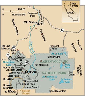
English: Map — Eruptions in the Lassen area in the last 50,000 years. |
|||
| Source | PD USGS image from http://pubs.usgs.gov/fs/2000/fs022-00/ | |||
| Author |
|
File history
Click on a date/time to view the file as it appeared at that time.
| Date/Time | Thumbnail | Dimensions | User | Comment | |
|---|---|---|---|---|---|
| current | 01:44, 25 September 2006 | | 335 × 378 (34 KB) | Mav (talk | contribs) | PD USGS image from http://pubs.usgs.gov/fs/2000/fs022-00/ {{PD-USGov-USGS}} Category:Lassen Volcanic National Park |
You cannot overwrite this file.
File usage on Commons
The following page uses this file:
File usage on other wikis
The following other wikis use this file:
- Usage on bn.wikipedia.org
- Usage on en.wikipedia.org
- Geology of the Lassen volcanic area
- Portal:Earth sciences
- Portal:California/Selected article
- Portal:Volcanoes/Selected article
- Portal:Volcanoes/Selected article/6
- User:Abyssal/Portal:Neogene/Natural world articles/38
- User:Abyssal/Portal:Cenozoic/Natural world articles/40
- Portal:California/Selected article/30
- Usage on fr.wikipedia.org
- Usage on it.wikipedia.org