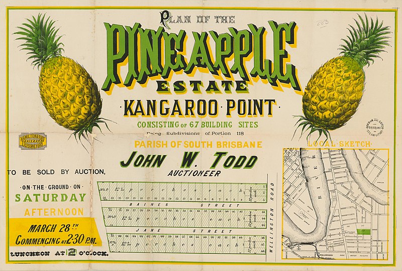
File:Estate map of the Pineapple Estate, Kangaroo Point, Brisbane, ca. 1890s (7505241522).jpg

Original file (4,000 × 2,699 pixels, file size: 1.35 MB, MIME type: image/jpeg)
Captions
Captions
Summary edit
| DescriptionEstate map of the Pineapple Estate, Kangaroo Point, Brisbane, ca. 1890s (7505241522).jpg |
English: Creator: John W. Todd, auctioneer. Hamilton & Raff, lic. surveyors. |
||
| Date | |||
| Source | https://www.flickr.com/photos/statelibraryqueensland/7505241522/ | ||
| Author | State Library of Queensland, Australia | ||
| Permission (Reusing this file) |
At the time of upload, the image license was automatically confirmed using the Flickr API. For more information see Flickr API detail. | ||
| Other versions |
|
||
| Flickr sets InfoField |
|
||
| Flickr tags InfoField |
|
| Camera location | 27° 28′ 40.84″ S, 153° 02′ 08.54″ E | View this and other nearby images on: OpenStreetMap |
|---|
Licensing edit
This image was taken from Flickr's The Commons. The uploading organization may have various reasons for determining that no known copyright restrictions exist, such as: No known copyright restrictionsNo restrictionshttps://www.flickr.com/commons/usage/false
More information can be found at https://flickr.com/commons/usage/. Please add additional copyright tags to this image if more specific information about copyright status can be determined. See Commons:Licensing for more information. |
| This image was originally posted to Flickr by State Library of Queensland, Australia at https://flickr.com/photos/32605636@N06/7505241522. It was reviewed on 25 November 2016 by FlickreviewR and was confirmed to be licensed under the terms of the No known copyright restrictions. |
25 November 2016
File history
Click on a date/time to view the file as it appeared at that time.
| Date/Time | Thumbnail | Dimensions | User | Comment | |
|---|---|---|---|---|---|
| current | 20:40, 25 November 2016 |  | 4,000 × 2,699 (1.35 MB) | Fæ (talk | contribs) | State Library of Queensland, Set 72157664799230183, ID 7505241522, Original title Estate map of the Pineapple Estate, Kangaroo Point, Brisbane, ca. 1890s |
You cannot overwrite this file.
File usage on Commons
The following page uses this file:
Metadata
This file contains additional information such as Exif metadata which may have been added by the digital camera, scanner, or software program used to create or digitize it. If the file has been modified from its original state, some details such as the timestamp may not fully reflect those of the original file. The timestamp is only as accurate as the clock in the camera, and it may be completely wrong.
| IIM version | 2 |
|---|
