File:Europe 1911.jpg

Size of this preview: 731 × 600 pixels. Other resolutions: 293 × 240 pixels | 585 × 480 pixels | 936 × 768 pixels | 1,248 × 1,024 pixels | 2,243 × 1,840 pixels.
Original file (2,243 × 1,840 pixels, file size: 1.88 MB, MIME type: image/jpeg)
Captions
Captions
Add a one-line explanation of what this file represents
Summary edit
| Description |
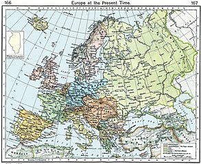
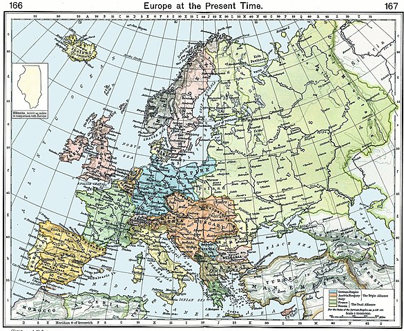
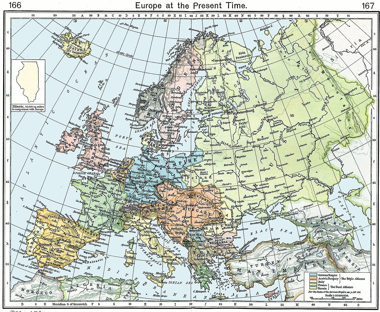
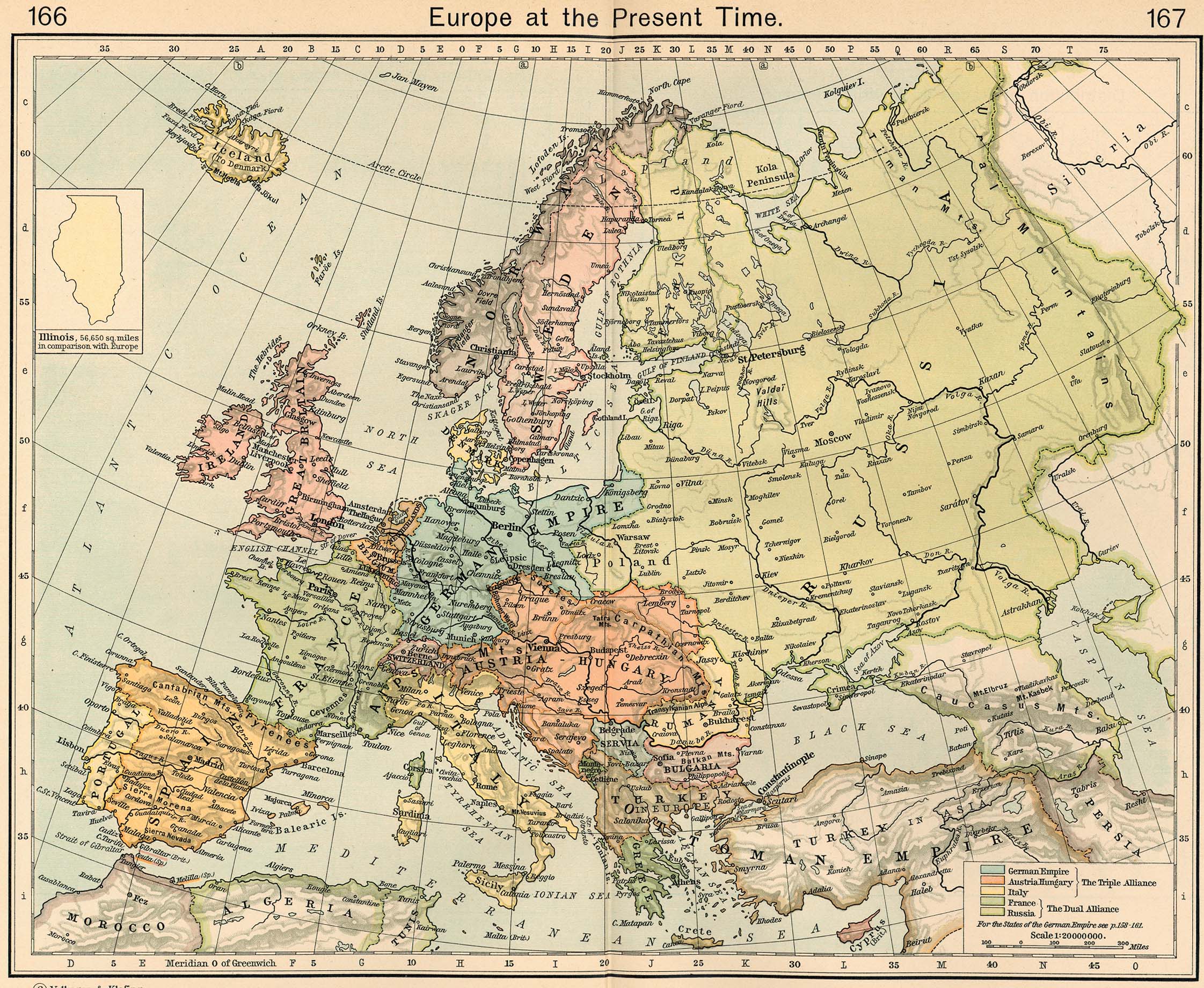
English: Europe in 1911 |
||||||||||||||||||||||
| Date | |||||||||||||||||||||||
| Source |
http://www.lib.utexas.edu/maps/historical/shepherd/europe_1911.jpg Originally published in Shepherd, William R. , ed. (1911) The Historical Atlas, Category:New York: Henry Holt and Co. OCLC: 3561632. |
||||||||||||||||||||||
| Author |
|
||||||||||||||||||||||
| Other versions |
Derivative works of this file: |
||||||||||||||||||||||
Licensing edit
|
This work is in the public domain in its country of origin and other countries and areas where the copyright term is the author's life plus 70 years or fewer. This work is in the public domain in the United States because it was published (or registered with the U.S. Copyright Office) before January 1, 1929. | |
| This file has been identified as being free of known restrictions under copyright law, including all related and neighboring rights. | |
_en.png)
.png)
.jpg)
File history
Click on a date/time to view the file as it appeared at that time.
| Date/Time | Thumbnail | Dimensions | User | Comment | |
|---|---|---|---|---|---|
| current | 07:54, 9 November 2022 | | 2,243 × 1,840 (1.88 MB) | Spectre-Ship (talk | contribs) | Correction of historic image not covered by COM:OW |
| 16:13, 19 September 2022 |  | 2,243 × 1,840 (3.69 MB) | Рагин1987 (talk | contribs) | Small correction | |
| 18:57, 27 September 2019 |  | 2,243 × 1,840 (1.88 MB) | Hohum (talk | contribs) | Reworked from original | |
| 21:17, 24 April 2009 |  | 2,243 × 1,840 (1.08 MB) | Alex:D (talk | contribs) | Whitened vers. | |
| 10:35, 8 May 2006 |  | 2,243 × 1,840 (848 KB) | Roke~commonswiki (talk | contribs) | Europe in 1911 {{Europe}} {{PD-PCL|http://www.lib.utexas.edu/maps/historical/shepherd/europe_1911.jpg}} Category: Historical maps of Europe |
You cannot overwrite this file.
File usage on Commons
The following 4 pages use this file:
File usage on other wikis
The following other wikis use this file:
- Usage on be-tarask.wikipedia.org
- Usage on de.wikipedia.org
- Usage on en.wikipedia.org
- Usage on et.wikipedia.org
- Usage on fa.wikipedia.org
- Usage on fr.wikipedia.org
- Usage on sk.wikipedia.org