File:Europe geological map-en.jpg

Size of this preview: 589 × 599 pixels. Other resolutions: 236 × 240 pixels | 472 × 480 pixels | 755 × 768 pixels | 1,006 × 1,024 pixels | 2,012 × 2,048 pixels | 5,408 × 5,504 pixels.
Original file (5,408 × 5,504 pixels, file size: 6.99 MB, MIME type: image/jpeg)
Captions
Captions
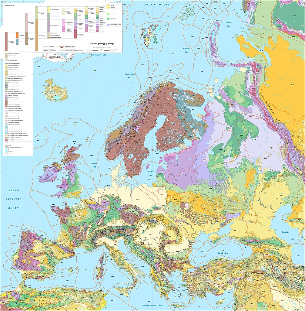
Surficial geology of Europe
Summary edit
| Description |
English: Map in English of the surficial geology of Europe.
Notes: For translations use the SVG version. A list of the names corresponding to the geologic provinces codes displayed on the map can be viewed on this page. Français : Carte en anglais de la géologie de surface de l'Europe.
Notes : Pour les traductions utiliser la version SVG. Une liste des noms anglophones correspondant aux codes des provinces géologiques de la carte peut être consultée sur la cette page. Lambert Azimuthal Equal-Area projection - ETRS89 datum |
||
| Date | |||
| Source |
Own work
|
||
| Author | Eric Gaba (Sting - fr:Sting) | ||
| Permission (Reusing this file) |
|
||
| Other versions |
Derivative works of this file: Europe geological map-detail-France-en.jpg
|


Licensing edit
Eric Gaba, Wikimedia Commons user Sting, the copyright holder of this work, hereby publishes it under the following license:
This file is licensed under the Creative Commons Attribution-Share Alike 3.0 Unported license.
Attribution: Eric Gaba, Wikimedia Commons user Sting
- You are free:
- to share – to copy, distribute and transmit the work
- to remix – to adapt the work
- Under the following conditions:
- attribution – You must give appropriate credit, provide a link to the license, and indicate if changes were made. You may do so in any reasonable manner, but not in any way that suggests the licensor endorses you or your use.
- share alike – If you remix, transform, or build upon the material, you must distribute your contributions under the same or compatible license as the original.
File history
Click on a date/time to view the file as it appeared at that time.
| Date/Time | Thumbnail | Dimensions | User | Comment | |
|---|---|---|---|---|---|
| current | 18:27, 25 September 2019 | | 5,408 × 5,504 (6.99 MB) | Sting (talk | contribs) | Typo correction ; color profile |
| 17:54, 13 August 2010 |  | 5,408 × 5,504 (5.74 MB) | Sting (talk | contribs) | == {{int:filedesc}} == {{Location|60|00|00|N|20|00|00|E|scale:20000000}} <br/> {{Information| |Description={{en|Map in English of the surficial geology of Europe.<br/>''Note: For translations use the [[:File:Europe_geological_map |
You cannot overwrite this file.
File usage on Commons
The following 4 pages use this file:
File usage on other wikis
The following other wikis use this file:
- Usage on ba.wikipedia.org
- Usage on ca.wikipedia.org
- Usage on de.wikipedia.org
- Usage on en.wikipedia.org
- Europe
- Geology of the Alps
- Eurasian Plate
- Karelides
- Geology of Great Britain
- Anatolian Sub-Plate
- Alpine orogeny
- Avalonia
- Timan-Pechora Basin
- Uralian orogeny
- Caspian Depression
- Geology of Europe
- Geology of Scotland
- Geology of the Netherlands
- Piemont-Liguria Ocean
- Adriatic Plate
- East European Craton
- Sarmatian Craton
- Ukrainian Shield
- Geology of Iceland
- Geology of the Faroe Islands
- Baltic Plate
- Geology of England
- Cadomian Orogeny
- Geology of Wales
- Geology of Ireland
- Geology of Turkey
- Geology of Norway
- Geology of the Iberian Peninsula
- Template:Geology of Europe
- Geology of Andorra
- Geology of Guernsey
- Geology of Jersey
- Geology of Alderney
- Rhenohercynian Zone
- Geology of the North Sea
- Saxothuringian Zone
- Aegean Sea Plate
- Moldanubian Zone
- Geology of the Western Carpathians
- Iberian Plate
- Geology of the Massif Central
- Geology of the Pyrenees
- European Cenozoic Rift System
- User:GeoWriter/Sandbox2
- Hellenic Trench
View more global usage of this file.