File:Executors sale of property belonging to the estate of Jordan Coles, decd. - situate in the 6th ward of the city of Brooklyn, by Jas. Bleecker and Sons on Thursday, 2nd June 1836, at 12 o'clock at NYPL465034.tiff

Size of this JPG preview of this TIF file: 447 × 600 pixels. Other resolutions: 179 × 240 pixels | 358 × 480 pixels | 572 × 768 pixels | 763 × 1,024 pixels | 1,527 × 2,048 pixels | 4,392 × 5,891 pixels.
Original file (4,392 × 5,891 pixels, file size: 74.03 MB, MIME type: image/tiff)
Captions
Captions
Add a one-line explanation of what this file represents
Summary edit
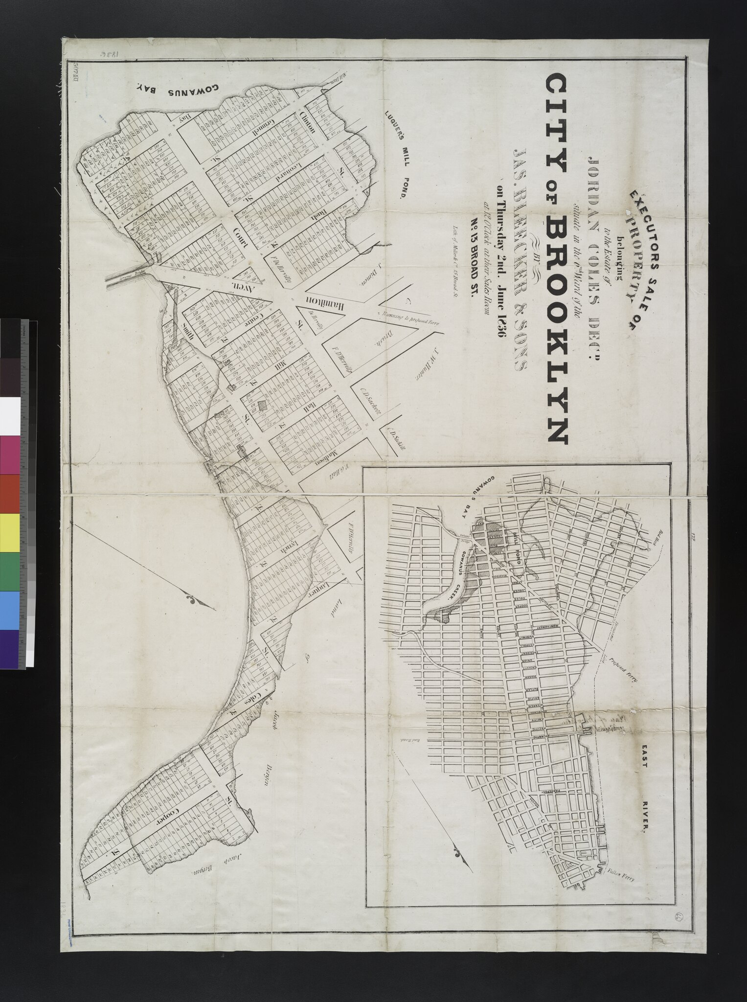
| Description | Executors sale of property belonging to the estate of Jordan Coles, decd. : situate in the 6th ward of the city of Brooklyn, by Jas. Bleecker and Sons on Thursday, 2nd June 1836, at 12 o'clock at their sales room, No. 13 Broad St.; Maps of New York City and State / New York City / Brooklyn | |||||||||||||||||||||||
| Notes | Covers area along the north shore of Gowanus Creek, including parts of Clinton, Court, and Smith streets, between Bay Street and Cooper Street. ''Note 2.'') Includes location map inset. ''Note 3.'') National Endowment for the Humanities Grant for Access to Early Maps of the Middle Atlantic Seaboard. ''Note 4.'') Shows lots and dimensions, and names of owners of adjoining properties. Also shows mill, pond, and marshy areas along Gowanus Bay and Creek, as well as selected buildings. ''Note 5.'') Oriented with north toward the upper right. | |||||||||||||||||||||||
| Item physical description | 1 map ; 63 x 89 cm. | |||||||||||||||||||||||
| Catalogue call number | Map Div. 02-343 | |||||||||||||||||||||||
| Date | circa 1836 | |||||||||||||||||||||||
| Source |
http://digitalgallery.nypl.org/nypldigital/dgkeysearchdetail.cfm?imageID=465034
|
|||||||||||||||||||||||
| Author | ||||||||||||||||||||||||
| Permission (Reusing this file) |
From The Lionel Pincus and Princess Firyal Map Division. http://maps.nypl.org
|
|||||||||||||||||||||||
| Location | Stephen A. Schwarzman Building / The Lionel Pincus and Princess Firyal Map Division | |||||||||||||||||||||||
| Digital item published | 2-3-2004; updated 5-16-2012 | |||||||||||||||||||||||
| Digital ID | 465034 | |||||||||||||||||||||||

The making of this file was supported by Wikimedia UK.
To see other files made with the support of Wikimedia UK, please see the category Supported by Wikimedia UK.
|
File history
Click on a date/time to view the file as it appeared at that time.
| Date/Time | Thumbnail | Dimensions | User | Comment | |
|---|---|---|---|---|---|
| current | 06:55, 28 April 2014 |  | 4,392 × 5,891 (74.03 MB) | Fæ (talk | contribs) | GWToolset:: Creating mediafile for Fæ. Tranche 3 5495-7474 (2) |
You cannot overwrite this file.
File usage on Commons
There are no pages that use this file.