File:Export destinations of Iranian drones (2023).png

Size of this preview: 800 × 354 pixels. Other resolutions: 320 × 141 pixels | 640 × 283 pixels | 1,278 × 565 pixels.
Original file (1,278 × 565 pixels, file size: 329 KB, MIME type: image/png)
Captions
Captions
Add a one-line explanation of what this file represents
Summary edit
.png&action=edit§ion=1)
| Description |
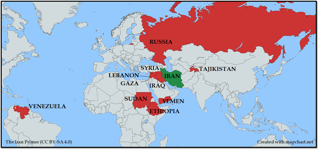
English (en): Export destinations of Iranian drones as of February 2023
Iran Countries where Iranian-made drones are imported.
|
| Date | |
| Source | https://iranprimer.usip.org/blog/2022/nov/16/explainer-iran%E2%80%99s-drone-exports-worldwide (Direct URL: https://iranprimer.usip.org/sites/default/files/drone%20exports%202022/Drone%20Export%20Map%20v2.png) |
| Author |
|
| Other versions | The license of this map (CC BY-SA 4.0) is visible on bottom left. |
Licensing edit
.png&action=edit§ion=2)
| This map was created for free at MapChart.net. All maps created there are licensed under the Creative Commons Attribution-ShareAlike 4.0 International License. See the "Licensing" link on the home page, or the MapChart.net feedback page for the image license info, and this MapChart.net Commons discussion. Use {{Mapchart.net}} to provide attribution for maps created with that service.
See also: Other maps on Commons created with Mapchart.net: Category:Mapchart.net and this search query; other map and chart resources. |
This file is licensed under the Creative Commons Attribution-Share Alike 4.0 International license.
Attribution: The Iran Primer
- You are free:
- to share – to copy, distribute and transmit the work
- to remix – to adapt the work
- Under the following conditions:
- attribution – You must give appropriate credit, provide a link to the license, and indicate if changes were made. You may do so in any reasonable manner, but not in any way that suggests the licensor endorses you or your use.
- share alike – If you remix, transform, or build upon the material, you must distribute your contributions under the same or compatible license as the original.

|
This file, which was originally posted to an external website, has not yet been reviewed by an administrator or reviewer to confirm that the above license is valid. See Category:License review needed for further instructions.
|
File history
Click on a date/time to view the file as it appeared at that time.
| Date/Time | Thumbnail | Dimensions | User | Comment | |
|---|---|---|---|---|---|
| current | 16:55, 6 May 2023 | | 1,278 × 565 (329 KB) | HeminKurdistan (talk | contribs) | Cropped 2 % horizontally, 8 % vertically using CropTool with precise mode. |
| 16:44, 6 May 2023 |  | 1,300 × 614 (324 KB) | HeminKurdistan (talk | contribs) | Uploaded a work by The Iran Primer using website mapchart.net from https://iranprimer.usip.org/blog/2022/nov/16/explainer-iran%E2%80%99s-drone-exports-worldwide with UploadWizard |
You cannot overwrite this file.
File usage on Commons
There are no pages that use this file.
File usage on other wikis
The following other wikis use this file:
- Usage on ar.wikipedia.org
- Usage on fa.wikipedia.org
.png&oldid=760340178)