File:FRONT PORTICO ELEMENTS- COLUMNS, CORNICE AND RAILING - Hext House, 207 Handcock Street, Beaufort, Beaufort County, SC HABS SC,7-BEAUF,11-10.tif

Size of this JPG preview of this TIF file: 751 × 600 pixels. Other resolutions: 301 × 240 pixels | 601 × 480 pixels | 962 × 768 pixels | 1,280 × 1,022 pixels | 2,560 × 2,045 pixels | 5,000 × 3,994 pixels.
Original file (5,000 × 3,994 pixels, file size: 19.05 MB, MIME type: image/tiff)
Captions
Captions
Add a one-line explanation of what this file represents
Summary edit
| FRONT PORTICO ELEMENTS- COLUMNS, CORNICE AND RAILING - Hext House, 207 Handcock Street, Beaufort, Beaufort County, SC | ||||
|---|---|---|---|---|
| Title |
FRONT PORTICO ELEMENTS- COLUMNS, CORNICE AND RAILING - Hext House, 207 Handcock Street, Beaufort, Beaufort County, SC |
|||
| Depicted place | South Carolina; Beaufort County; Beaufort | |||
| Date | Documentation compiled after 1933 | |||
| Dimensions | 4 x 5 in. | |||
| Current location |
Library of Congress Prints and Photographs Division Washington, D.C. 20540 USA http://hdl.loc.gov/loc.pnp/pp.print |
|||
| Accession number |
HABS SC,7-BEAUF,11-10 |
|||
| Credit line |
|
|||
| Notes |
|
|||
| Source | https://www.loc.gov/pictures/item/sc0041.photos.151315p | |||
| Permission (Reusing this file) |
|
|||

| Object location | | View this and other nearby images on: OpenStreetMap |
|---|
File history
Click on a date/time to view the file as it appeared at that time.
| Date/Time | Thumbnail | Dimensions | User | Comment | |
|---|---|---|---|---|---|
| current | 23:19, 1 August 2014 | 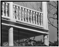 | 5,000 × 3,994 (19.05 MB) | Fæ (talk | contribs) | GWToolset: Creating mediafile for Fæ. HABS 31 July 2014 (3000:3200) |
You cannot overwrite this file.
File usage on Commons
The following page uses this file: