File:FUSRAP site in USA.jpg

Size of this preview: 800 × 456 pixels. Other resolutions: 320 × 183 pixels | 640 × 365 pixels | 1,024 × 584 pixels | 1,450 × 827 pixels.
Original file (1,450 × 827 pixels, file size: 126 KB, MIME type: image/jpeg)
Captions
Captions
Add a one-line explanation of what this file represents
Summary edit
| Description |
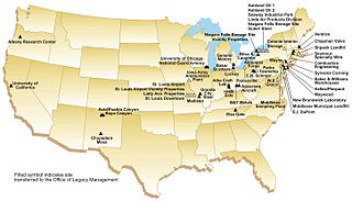
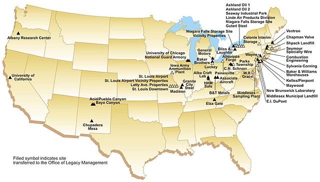
English: The Formerly Utilized Sites Remedial Action Program (FUSRAP) is an environmental cleanup program of radiation contamination. This map indicate site involved in this program. 日本語: 米国のFUSRAPのプログラム実施地点。 |
| Date | |
| Source | http://www.mvs.usace.army.mil/eng-con/expertise/fusrap-what.html |
| Author | US Army Corps of Engineers |
Licensing edit
This file is a work of a U.S. Army soldier or employee, taken or made as part of that person's official duties. As a work of the U.S. federal government, it is in the public domain in the United States.
|
 |
File history
Click on a date/time to view the file as it appeared at that time.
| Date/Time | Thumbnail | Dimensions | User | Comment | |
|---|---|---|---|---|---|
| current | 00:50, 17 November 2011 | | 1,450 × 827 (126 KB) | Masaqui (talk | contribs) |
You cannot overwrite this file.
File usage on Commons
There are no pages that use this file.
File usage on other wikis
The following other wikis use this file:
- Usage on en.wikipedia.org
- Usage on ja.wikipedia.org