File:F 18 Tullinge 23.jpg

Size of this preview: 800 × 450 pixels. Other resolutions: 320 × 180 pixels | 640 × 360 pixels | 1,024 × 576 pixels | 1,280 × 720 pixels | 2,560 × 1,440 pixels | 4,000 × 2,250 pixels.
Original file (4,000 × 2,250 pixels, file size: 2.82 MB, MIME type: image/jpeg)
Captions
Captions
Add a one-line explanation of what this file represents
Summary edit
| Description |
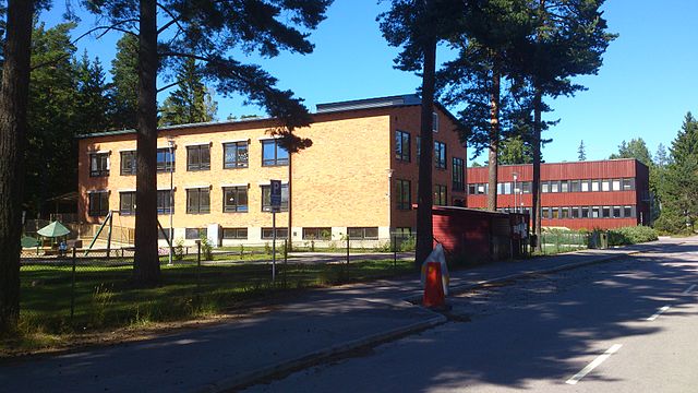
Svenska: "Gamla skolhuset" (gula tegelbyggnaden). Där fanns lektionssalar och bibliotek. I källaren låg flottiljens "gymnastiksal", fram till att den nya gymnastiksalen mellan kanslihuset och Hangar 81 blev klar 1974. Från den 1 juli 1974 blev hela skolhuset KAS/M byggnad. FTTS flyttade samtidigt in i den då helt nybyggda röda byggnaden i bakgrunden. Skolorna verkade i Tullinge mellan åren 1974 och 1984. |
| Date | |
| Source | Own work |
| Author | Joshua06 |
| Camera location | | View this and other nearby images on: OpenStreetMap |
|---|
Licensing edit
I, the copyright holder of this work, hereby publish it under the following license:
This file is licensed under the Creative Commons Attribution-Share Alike 3.0 Unported license.
- You are free:
- to share – to copy, distribute and transmit the work
- to remix – to adapt the work
- Under the following conditions:
- attribution – You must give appropriate credit, provide a link to the license, and indicate if changes were made. You may do so in any reasonable manner, but not in any way that suggests the licensor endorses you or your use.
- share alike – If you remix, transform, or build upon the material, you must distribute your contributions under the same or compatible license as the original.
File history
Click on a date/time to view the file as it appeared at that time.
| Date/Time | Thumbnail | Dimensions | User | Comment | |
|---|---|---|---|---|---|
| current | 14:23, 4 August 2013 | | 4,000 × 2,250 (2.82 MB) | Joshua06 (talk | contribs) | User created page with UploadWizard |
You cannot overwrite this file.
File usage on Commons
The following page uses this file:
File usage on other wikis
The following other wikis use this file:
- Usage on sv.wikipedia.org