File:Falkland Islands topographic map-fr.svg

Size of this PNG preview of this SVG file: 768 × 599 pixels. Other resolutions: 308 × 240 pixels | 615 × 480 pixels | 984 × 768 pixels | 1,280 × 999 pixels | 2,560 × 1,998 pixels | 2,550 × 1,990 pixels.
Original file (SVG file, nominally 2,550 × 1,990 pixels, file size: 1.93 MB)
Captions
Captions
Add a one-line explanation of what this file represents
This SVG map uses required raster graphics to show delicate structures.
![]()
Detailed map of large dimension. For a better viewing, click on the link of the image above.
Carte détaillée de grande dimension. Pour une visualisation optimale, cliquer sur le lien de l'image ci-dessus.
Summary edit
| Description |
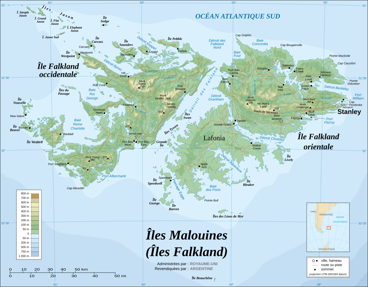
English: Topographic map of the Falkland Islands (in French). The Falkland Islands are an archipelago in the South Atlantic Ocean, located 300 miles off the coast of Argentina. They consist of two main islands, East Falkland and West Falkland, together with about 700 smaller islands. Stanley, on East Falkland, is the capital and largest city. The islands are a self-governing Overseas Territory of the United Kingdom.
Français : Carte topographique des Îles Malouines. Les Malouines forment un archipel dans l'Océan Atlantique Sud à 480 km des côtes argentines. Il est composé de deux îles principales, East Falkland et West Falkland, et de 700 autres îles et îlots. Stanley, sur East Falkland, est la capitale et la plus grande agglomération de l'archipel. Les Malouines sont un territoire autonome du Royaume-Uni. |
||
| Date | November 2007 using elements from the original version of April 2007 | ||
| Source |
Own work ; Topographic map : NASA Shuttle Radar Topography Mission (SRTM3 v.2) (public domain) edited with dlgv32 Pro/Global Mapper and vectorized with Inkscape ; UTM projection ; WGS84 datum ; shaded relief (composite image of N-W, W and N lightning positions) ; Approximate scale of topographic data and shore / lakes limits : 1:705,000 ; of the bathymetry : 1:3.720.000 Bathymetry : USGov public domain data provided by the Demis add-on for World Wind (see the approval e-mail) ; Other references used for additional data : * UK government map ; * NASA World Wind ; * CIA map available on the site of the University of Texas at Austin ; * Microsoft Encarta atlas (1999 edition). Note : The shaded relief is a raster image embedded in the SVG file which increases its size. If you want a lighter map for other purposes, delete the shaded relief image in your file. |
||
| Author | Eric Gaba (Sting - fr:Sting) | ||
| Permission (Reusing this file) |
|
||
| Other versions |
[]
|


.svg)


.svg)


|
This SVG file contains embedded text that can be translated into your language, using any capable SVG editor, text editor or the SVG Translate tool. For more information see: About translating SVG files. |
Licensing edit
I, the copyright holder of this work, hereby publish it under the following licenses:

|
Permission is granted to copy, distribute and/or modify this document under the terms of the GNU Free Documentation License, Version 1.2 or any later version published by the Free Software Foundation; with no Invariant Sections, no Front-Cover Texts, and no Back-Cover Texts. A copy of the license is included in the section entitled GNU Free Documentation License. |
| This file is licensed under the Creative Commons Attribution-Share Alike 3.0 Unported license. | ||
| ||
| This licensing tag was added to this file as part of the GFDL licensing update. |
This file is licensed under the Creative Commons Attribution-Share Alike 2.5 Generic, 2.0 Generic and 1.0 Generic license.
- You are free:
- to share – to copy, distribute and transmit the work
- to remix – to adapt the work
- Under the following conditions:
- attribution – You must give appropriate credit, provide a link to the license, and indicate if changes were made. You may do so in any reasonable manner, but not in any way that suggests the licensor endorses you or your use.
- share alike – If you remix, transform, or build upon the material, you must distribute your contributions under the same or compatible license as the original.
You may select the license of your choice.
File history
Click on a date/time to view the file as it appeared at that time.
| Date/Time | Thumbnail | Dimensions | User | Comment | |
|---|---|---|---|---|---|
| current | 18:49, 16 November 2007 | | 2,550 × 1,990 (1.93 MB) | Sting (talk | contribs) | New background ; some names correction / addition ; - 1982 CIA census data |
| 19:13, 5 April 2007 |  | 2,550 × 1,990 (2.03 MB) | Sting (talk | contribs) | Enhanced shaded relief | |
| 05:09, 5 April 2007 |  | 2,550 × 1,990 (1.86 MB) | Sting (talk | contribs) | {{Information |Description={{en}}The '''Falkland Islands''' are an archipelago in the South Atlantic Ocean, located 300 miles off the coast of Argentina. They consist of two main islands, East Falkland and West Falkland, together with about 700 smalle |
You cannot overwrite this file.
File usage on Commons
The following 27 pages use this file:
- Falkland Islands
- User:SVGbot/Results
- File:Falkland Islands map shaded relief-en.svg
- File:Falkland Islands map shaded relief-fr.svg
- File:Falkland Islands topographic map-ca.svg
- File:Falkland Islands topographic map-da.svg
- File:Falkland Islands topographic map-de.svg
- File:Falkland Islands topographic map-en.svg
- File:Falkland Islands topographic map-en librsvg.png
- File:Falkland Islands topographic map-en rendersvg.png
- File:Falkland Islands topographic map-es.svg
- File:Falkland Islands topographic map-es (argentinian names places).svg
- File:Falkland Islands topographic map-fr.svg
- File:Falkland Islands topographic map-hr.svg
- File:Falkland Islands topographic map-it.svg
- File:Falkland Islands topographic map-ka.svg
- File:Falkland Islands topographic map-mk.svg
- File:Falkland Islands topographic map-nb.svg
- File:Falkland Islands topographic map-nl.svg
- File:Falkland Islands topographic map-nn.svg
- File:Falkland Islands topographic map-pl.svg
- File:Falkland Islands topographic map-pt (argentinian names places).svg
- File:Falkland Islands topographic map-ru.svg
- File:Falkland Islands topographic map-sr.svg
- File:Falkland Islands topographic map-zh-hans.svg
- File:Iles Malouines carte.svg
- Template:Other versions/Falkland Islands topographic map
File usage on other wikis
The following other wikis use this file:
- Usage on azb.wikipedia.org
- Usage on fr.wikipedia.org