File:Farm bridge over stream - geograph.org.uk - 1061524.jpg

Size of this preview: 631 × 599 pixels. Other resolutions: 253 × 240 pixels | 505 × 480 pixels | 640 × 608 pixels.
Original file (640 × 608 pixels, file size: 179 KB, MIME type: image/jpeg)
Captions
Captions
Add a one-line explanation of what this file represents
Summary edit
| Description |
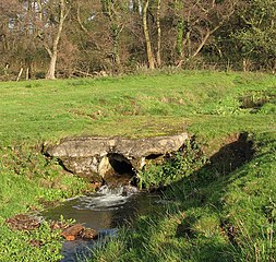
English: Farm bridge over stream. In a cattle pasture that is traversed by a narrow and not very well defined path which continues where Granary Lane ends, at a gate leading into this pasture > 1061478. Granary Lane doubles as a public footpath, turning off Market Street in westerly direction > 1061413. Here it peters out into a narrow path > 1061469 - 1061485 which emerges on a farm track by The Street in St James > 1061613. |
| Date | |
| Source | From geograph.org.uk |
| Author | Evelyn Simak |
| Attribution (required by the license) | Evelyn Simak / Farm bridge over stream / |
| Camera location | | View this and other nearby images on: OpenStreetMap |
|---|
_heading:22.00&language=en)
| Object location | | View this and other nearby images on: OpenStreetMap |
|---|
_heading:22.00&language=en)
Licensing edit

|
This image was taken from the Geograph project collection. See this photograph's page on the Geograph website for the photographer's contact details. The copyright on this image is owned by Evelyn Simak and is licensed for reuse under the Creative Commons Attribution-ShareAlike 2.0 license.
|
This file is licensed under the Creative Commons Attribution-Share Alike 2.0 Generic license.
Attribution: Evelyn Simak
- You are free:
- to share – to copy, distribute and transmit the work
- to remix – to adapt the work
- Under the following conditions:
- attribution – You must give appropriate credit, provide a link to the license, and indicate if changes were made. You may do so in any reasonable manner, but not in any way that suggests the licensor endorses you or your use.
- share alike – If you remix, transform, or build upon the material, you must distribute your contributions under the same or compatible license as the original.
File history
Click on a date/time to view the file as it appeared at that time.
| Date/Time | Thumbnail | Dimensions | User | Comment | |
|---|---|---|---|---|---|
| current | 03:56, 24 February 2011 | | 640 × 608 (179 KB) | GeographBot (talk | contribs) | == {{int:filedesc}} == {{Information |description={{en|1=Farm bridge over stream In a cattle pasture that is traversed by a narrow and not very well defined path which continues where Granary Lane ends, at a gate leading into this pasture > http://www.geo |
You cannot overwrite this file.
File usage on Commons
There are no pages that use this file.