File:Fifteenth Street Financial Historic District map.jpg
Size of this preview: 339 × 600 pixels. Other resolutions: 135 × 240 pixels | 478 × 846 pixels.
Original file (478 × 846 pixels, file size: 142 KB, MIME type: image/jpeg)
Captions
Captions
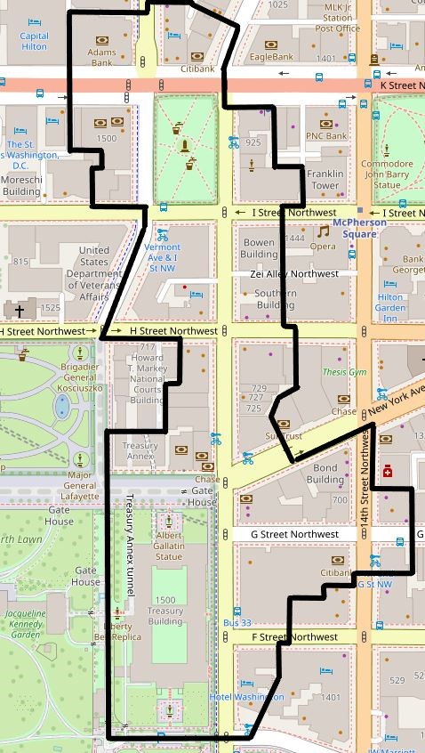
Fifteenth Street Financial Historic District map
| Description |
English: Map showing the boundaries of the Financial Historic District (previously known as the Fifteenth Street Financial Historic District) in Washington, D.C. The historic district is listed on the National Register of Historic Places. Boundaries are derived from the map provided by the District of Columbia's Office of Planning. |
|||||||||
| Date | ||||||||||
| Source | Screenshot of OpenStreetMap's map of the Financial Historic District vicinity, with district boundary lines drawn by uploader | |||||||||
| Creator |
OpenStreetMap editors (map), APK (district boundaries) |
|||||||||
| Permission (Reusing this file) |
My work is public domain, and the original map is This file is licensed under the Creative Commons Attribution 2.0 Generic license.
|
|||||||||
| Geotemporal data | ||||||||||
| Bounding box |
|
|||||||||
| Georeferencing | ||||||||||
File history
Click on a date/time to view the file as it appeared at that time.
| Date/Time | Thumbnail | Dimensions | User | Comment | |
|---|---|---|---|---|---|
| current | 04:01, 31 October 2023 | | 478 × 846 (142 KB) | APK (talk | contribs) | Uploaded own work with UploadWizard |
You cannot overwrite this file.
File usage on Commons
There are no pages that use this file.
File usage on other wikis
The following other wikis use this file:
- Usage on en.wikipedia.org