File:Finnmarkens amt nr 46-0- Kart over Grændsen mellom Norge og Russland, 1896.jpg

Size of this preview: 534 × 599 pixels. Other resolutions: 214 × 240 pixels | 428 × 480 pixels | 684 × 768 pixels | 913 × 1,024 pixels | 1,825 × 2,048 pixels | 7,100 × 7,967 pixels.
Original file (7,100 × 7,967 pixels, file size: 5.89 MB, MIME type: image/jpeg)
Captions
Captions
Add a one-line explanation of what this file represents
Summary edit
| Title |
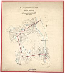
Norsk bokmål: Finnmarkens amt nr 46-0: Kart over Grændsen mellom Norge og Russland, 1896 |
||||||||||||||||||||||||||
| Description |
Norsk bokmål: Håndtegnet/fotoalgrafi |
||||||||||||||||||||||||||
| Date | |||||||||||||||||||||||||||
| Source |
|
||||||||||||||||||||||||||
| Creator |
W. Haffner, E. A. Eriksen |
||||||||||||||||||||||||||
| Permission (Reusing this file) |
This file is licensed under the Creative Commons Attribution 4.0 International license.
|
||||||||||||||||||||||||||
| Geotemporal data | |||||||||||||||||||||||||||
| Date depicted | |||||||||||||||||||||||||||
| Map location | Finnmark (Finnmark) | ||||||||||||||||||||||||||
| Scale | 1:42,000 | ||||||||||||||||||||||||||
| Georeferencing | If inappropriate please set warp_status = skip to hide. | ||||||||||||||||||||||||||
| Bibliographic data | |||||||||||||||||||||||||||
| Part of the series | Category:Finnmarken county | ||||||||||||||||||||||||||
| Map sheet | 46-0 | ||||||||||||||||||||||||||
| Language | Norwegian | ||||||||||||||||||||||||||
| Archival data | |||||||||||||||||||||||||||
| Collection |
|
||||||||||||||||||||||||||
| Accession number | |||||||||||||||||||||||||||
| Medium | Fotoalgrafi | ||||||||||||||||||||||||||
File history
Click on a date/time to view the file as it appeared at that time.
| Date/Time | Thumbnail | Dimensions | User | Comment | |
|---|---|---|---|---|---|
| current | 09:25, 29 October 2015 | | 7,100 × 7,967 (5.89 MB) | Artturimatias (talk | contribs) | GWToolset: Creating mediafile for Artturimatias. |
You cannot overwrite this file.
File usage on Commons
There are no pages that use this file.
File usage on other wikis
The following other wikis use this file:
- Usage on fi.wikipedia.org
- Usage on sv.wikipedia.org