File:Fires in California (MODIS 2018-11-14).jpg

Original file (3,117 × 2,657 pixels, file size: 833 KB, MIME type: image/jpeg)
Captions
Captions
Summary edit
.jpg&action=edit§ion=1)
| Description |
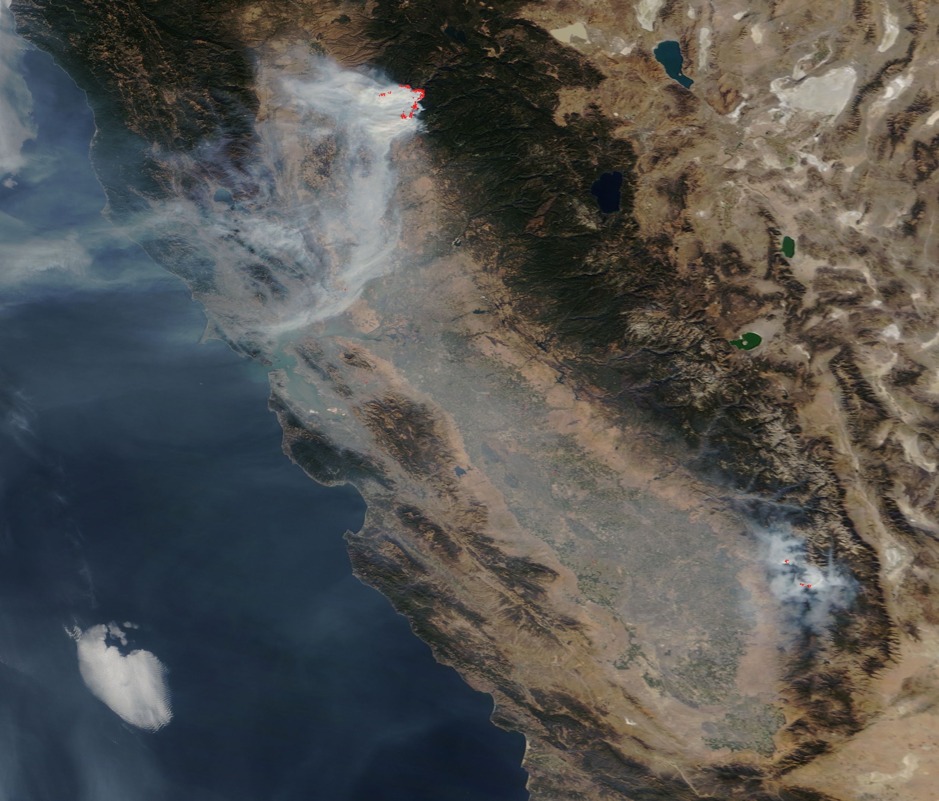
English: A record-breaking fire season continued to blaze through California in mid-November, 2018, with the Camp Fire becoming not only the most costly fire in the state’s history, but also the deadliest. The Moderate Resolution Imaging Spectroradiometer (MODIS) on board NASA’s Terra satellite acquired a true-color image of several fires and thick smoke over much of California on November 12.
The most remarkable and largest sets of red hot spots in northern California marked the very active and aggressive Camp Fire. By 9:30 p.m. on November 13, the Camp Fire was responsible for 48 deaths, with reports of more than 100 residents missing. More than 7,000 structures have been destroyed by this one blaze, which began on November 8. It is also the most destructive in California history as well with 8,817 structures destroyed including 7,000 homes. The fire has consumed 130,000 acres in just under a week and is reported to be only 35% contained. The cause of this blaze is still under investigation. In the southeast a cluster of hot spots marks fires burning in Sequoia National Forest. These include the Alder, Mountain, and Moses Fires which were ignited by lightning strikes on October 4. The Alder and Mountaineer Fires are burning in timber, with heavy fuels on the ground, in an area of extensive tree mortality. Moses Fire is burning in a patch of timber near a rocky area. They have burned a total of 3,700 acres to date and are 55% contained. Extremely dry fuels from on-going drought conditions in California remain coupled with rugged terrain and these two issues are presenting firefighters with challenging conditions. Dry conditions with high winds contribute to massive and fast fire growth. Responders from across the country have joined the effort from Wyoming, Washington, Oregon, New Mexico, Nevada, Arizona, Utah, Colorado, South Dakota and Nebraska. |
||
| Date | Taken on 12 November 2018 | ||
| Source |
Fires in California (direct link)
|
||
| Author | MODIS Land Rapid Response Team, NASA GSFC |
| This media is a product of the Terra mission Credit and attribution belongs to the mission team, if not already specified in the "author" row |
Licensing edit
.jpg&action=edit§ion=2)
| This file is in the public domain in the United States because it was solely created by NASA. NASA copyright policy states that "NASA material is not protected by copyright unless noted". (See Template:PD-USGov, NASA copyright policy page or JPL Image Use Policy.) | ||
 |
Warnings:
|
File history
Click on a date/time to view the file as it appeared at that time.
| Date/Time | Thumbnail | Dimensions | User | Comment | |
|---|---|---|---|---|---|
| current | 01:23, 17 February 2024 | | 3,117 × 2,657 (833 KB) | OptimusPrimeBot (talk | contribs) | #Spacemedia - Upload of http://modis.gsfc.nasa.gov/gallery/images/image11142018_250m.jpg via Commons:Spacemedia |
You cannot overwrite this file.
File usage on Commons
There are no pages that use this file.
.jpg&oldid=852732141)