File:First Floor Plan - National Home for Disabled Volunteer Soldiers, Mountain Branch, Administration Building, Lamont and Veterans Way, Johnson City, Washington County, TN HABS TN-254-Y (sheet 2 of 5).tif
Original file (14,400 × 9,600 pixels, file size: 744 KB, MIME type: image/tiff)
Captions
Captions
Summary edit
| Warning | The original file is very high-resolution. It might not load properly or could cause your browser to freeze when opened at full size. |
|---|
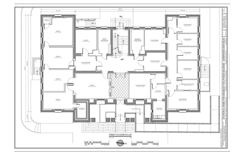
| First Floor Plan - National Home for Disabled Volunteer Soldiers, Mountain Branch, Administration Building, Lamont and Veterans Way, Johnson City, Washington County, TN | ||||
|---|---|---|---|---|
| Photographer |
McNatt, Jason W. |
|||
| Title |
First Floor Plan - National Home for Disabled Volunteer Soldiers, Mountain Branch, Administration Building, Lamont and Veterans Way, Johnson City, Washington County, TN |
|||
| Description |
U.S. Department of Veterans Affairs; Freedlander, J. H., Architect |
|||
| Depicted place | Tennessee; Washington County; Johnson City | |||
| Date | 2011 | |||
| Dimensions | 24 x 36 in. (D size) | |||
| Current location |
Library of Congress Prints and Photographs Division Washington, D.C. 20540 USA http://hdl.loc.gov/loc.pnp/pp.print |
|||
| Accession number |
HABS TN-254-Y (sheet 2 of 5) |
|||
| Credit line |
|
|||
| Notes |
The winning competition design for the Mountain Branch by New York architect Joseph H. Freedlander incorporated the latest ideas of comprehensive design and Neoclassicism as taught by the Ecole des Beaux Arts in Paris. Freedlander created a hierarchy of communal buildings, barracks, and service functions arranged along a central avenue with views south to the nearby mountains. The Administration Building serves as the western terminus of the main avenue, facing the Hospital. Eschewing the ornamentation and monumental scale of other structures such as the Mess Hall or Barracks, the understated red brick façade of the Administration Building created a transition to the officers' houses clustered behind and set a tone of sober efficiency for the Branch management.
|
|||
| Source | https://www.loc.gov/pictures/item/tn0420.sheet.00002a | |||
| Permission (Reusing this file) |
|
|||
| Other versions |
.png) .png) .png) |
|||

| Object location | | View this and other nearby images on: OpenStreetMap |
|---|
File history
Click on a date/time to view the file as it appeared at that time.
| Date/Time | Thumbnail | Dimensions | User | Comment | |
|---|---|---|---|---|---|
| current | 03:02, 2 August 2014 |  | 14,400 × 9,600 (744 KB) | Fæ (talk | contribs) | GWToolset: Creating mediafile for Fæ. HABS 2014-08-01 (3201:3400) |
You cannot overwrite this file.
File usage on Commons
The following page uses this file: