File:First Map - 1740s.jpg

Size of this preview: 800 × 503 pixels. Other resolutions: 320 × 201 pixels | 640 × 402 pixels | 1,024 × 644 pixels | 1,626 × 1,022 pixels.
Original file (1,626 × 1,022 pixels, file size: 541 KB, MIME type: image/jpeg)
Captions
Captions
Add a one-line explanation of what this file represents
Summary
edit
| Description |
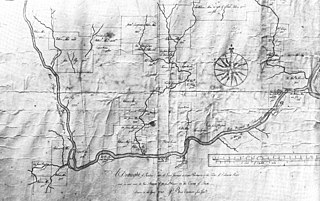
English: The Benjamin Eastburn Map of the west branch of the Lenhigh River, made in 1740. The plat of land owned by Judge William Allen, on which he founded the settlement of Northampton in 1762 is in the lower left of the map, at the confluence of the Lehigh River, Little Lehigh and Trout Creeks. The map is currently in the holdings of the Moravian Archives, Bethlehem, PA |
| Date | |
| Source | Allentown, 1762-1987, a 225 Year history, Volume I, 1762-1920, Lehigh County Historical Society, 1987. Chapter One, A History of Allentown: 1762-1810 |
| Author | Benjamin Eastburn |
Licensing
edit
|
This work is in the public domain in its country of origin and other countries and areas where the copyright term is the author's life plus 100 years or fewer. This work is in the public domain in the United States because it was published (or registered with the U.S. Copyright Office) before January 1, 1929. | |
| This file has been identified as being free of known restrictions under copyright law, including all related and neighboring rights. | |
File history
Click on a date/time to view the file as it appeared at that time.
| Date/Time | Thumbnail | Dimensions | User | Comment | |
|---|---|---|---|---|---|
| current | 23:47, 27 December 2014 | | 1,626 × 1,022 (541 KB) | Connor7617 (talk | contribs) | User created page with UploadWizard |
You cannot overwrite this file.
File usage on Commons
There are no pages that use this file.