File:First and Second Floor Plans - Roberts-Payne House, Dakota Street, South Pass City, Fremont County, WY HABS WYO,7-SOPAC,16- (sheet 1 of 3).tif

Size of this JPG preview of this TIF file: 760 × 600 pixels. Other resolutions: 304 × 240 pixels | 609 × 480 pixels | 974 × 768 pixels | 1,280 × 1,010 pixels | 2,560 × 2,020 pixels | 9,654 × 7,616 pixels.
Original file (9,654 × 7,616 pixels, file size: 454 KB, MIME type: image/tiff)
Captions
Captions
Add a one-line explanation of what this file represents
Summary edit
| First and Second Floor Plans - Roberts-Payne House, Dakota Street, South Pass City, Fremont County, WY | ||||
|---|---|---|---|---|
| Photographer |
Uhlir, John |
|||
| Title |
First and Second Floor Plans - Roberts-Payne House, Dakota Street, South Pass City, Fremont County, WY |
|||
| Description |
Roberts, Bolivar; Payne, Janet |
|||
| Depicted place | Wyoming; Fremont County; South Pass City | |||
| Date | 1973 | |||
| Dimensions | 19 x 24 in. (B size) | |||
| Current location |
Library of Congress Prints and Photographs Division Washington, D.C. 20540 USA http://hdl.loc.gov/loc.pnp/pp.print |
|||
| Accession number |
HABS WYO,7-SOPAC,16- (sheet 1 of 3) |
|||
| Credit line |
|
|||
| Notes |
|
|||
| Source | https://www.loc.gov/pictures/item/wy0087.sheet.00001a | |||
| Permission (Reusing this file) |
|
|||
| Other versions |
.png) |
|||

| Object location | | View this and other nearby images on: OpenStreetMap |
|---|
File history
Click on a date/time to view the file as it appeared at that time.
| Date/Time | Thumbnail | Dimensions | User | Comment | |
|---|---|---|---|---|---|
| current | 01:44, 5 August 2014 | 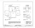 | 9,654 × 7,616 (454 KB) | Fæ (talk | contribs) | GWToolset: Creating mediafile for Fæ. HABS 2014-08-04 3801-4000 |
You cannot overwrite this file.
File usage on Commons
The following page uses this file: