File:Fisher School Bridge (7314980332).jpg
Original file (4,032 × 2,688 pixels, file size: 1.34 MB, MIME type: image/jpeg)
Captions
Captions
Summary edit
.jpg&action=edit§ion=1)
| Description |
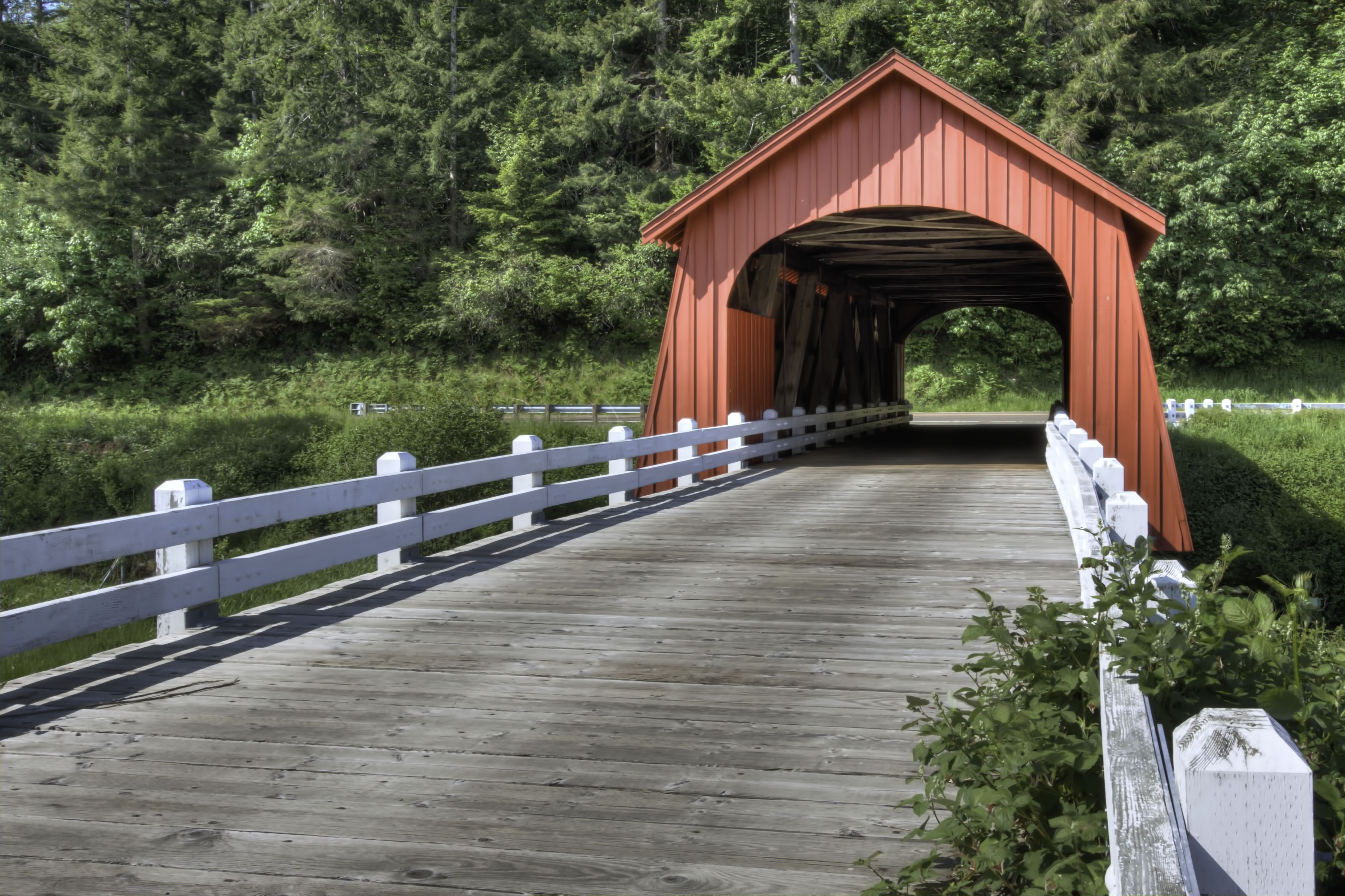
The Fisher Bridge is located in the rugged foothills of Lincoln County. The structure spans Five Rivers, so named because of the five streams of Alder Creek, Cougar Creek, Buck Creek, Crab Creek and Cherry Creek which make up the stream. According to a 1942 Lincoln County bridge report, the Fisher Bridge was built in 1927 at a cost of $1,800. The dispute in the date of construction may have been due to the renovation of the span in 1927. Other county records show the cost to build the span in 1919 was $2,500. According to George Melvin, a workman who helped to build the bridge, a group of farmers aided in construction by cutting large trees in the area which they shaped into logs with the use of broadaxes. After the main framework was completed, it was enclosed with lumber cut at the saw mill operated by the Olsen brothers. During the 1970s, residents of the Fisher community rallied to preserve the bridge, which was slated for demolition. Following construction of a concrete bridge a few feet away, Lincoln County invested about $2,000 to replace the rotted siding on the covered span. Among the supporters was Roy Olsen, a relative of the brothers who provided the lumber that was used to enclose the trusses during the original construction. Due to close proximity of the Fisher Elementary School, some refer to the covered bridge as the Fisher School Bridge. The area around Five Rivers was the site of other covered bridges, including the 36-foot Buck Creek Bridge built in 1924 and located 2 miles north of Fisher, and the Cascade Creek Bridge, also a 36-foot span built in 1927, just 2 miles west of Fisher. Only the Fisher Bridge remains. Design features include semi-elliptical portal arches, narrow ribbon openings under the side wall eaves, flared side walls and wood piers. |
| Date | |
| Source |
|
| Author | Sandy Horvath-Dori from Grand Junction, CO, USA |
| Camera location | | View this and other nearby images on: OpenStreetMap |
|---|
.jpg¶ms=044.293660_N_-123.844456_E_globe:Earth_type:camera_source:Flickr_&language=en)
Licensing edit
.jpg&action=edit§ion=2)
- You are free:
- to share – to copy, distribute and transmit the work
- to remix – to adapt the work
- Under the following conditions:
- attribution – You must give appropriate credit, provide a link to the license, and indicate if changes were made. You may do so in any reasonable manner, but not in any way that suggests the licensor endorses you or your use.
| This image, originally posted to Flickr, was reviewed on 2 February 2014 by the administrator or reviewer File Upload Bot (Magnus Manske), who confirmed that it was available on Flickr under the stated license on that date. |
File history
Click on a date/time to view the file as it appeared at that time.
| Date/Time | Thumbnail | Dimensions | User | Comment | |
|---|---|---|---|---|---|
| current | 02:11, 2 February 2014 | | 4,032 × 2,688 (1.34 MB) | File Upload Bot (Magnus Manske) (talk | contribs) | Transferred from Flickr by User:AlbertHerring |
You cannot overwrite this file.
File usage on Commons
There are no pages that use this file.
.jpg&oldid=755665990)