File:Flickr - Official U.S. Navy Imagery - A GOES-13 infrared satellite image of Hurricane Sandy..jpg

Original file (1,024 × 801 pixels, file size: 241 KB, MIME type: image/jpeg)
Captions
Captions
Summary
edit
| Description |
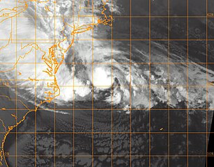
WASHINGTON (Oct. 29, 2012) A GOES-13 infrared satellite image of Hurricane Sandy provided by the U.S. Naval Research Laboratory (NRL) in Monterey, Calif., shows the storm at approximately 3:00 a.m.. EST in the Atlantic Ocean. (U.S. Navy photo/Released) 121029-N-ZZ999-001 Join the conversation www.facebook.com/USNavy www.twitter.com/USNavy navylive.dodlive.mil |
| Date | |
| Source | A GOES-13 infrared satellite image of Hurricane Sandy. |
| Author |
Official Navy Page from United States of America U.S. Navy photo/U.S. Navy |
| Permission (Reusing this file) |
Flinfo has extracted the license below from the metadata of the image (tag "IFD0:ImageDescription" contained "U.S. Navy photo"). The license visible at Flickr was "Attribution License". |
Licensing
edit
This file is a work of a sailor or employee of the U.S. Navy, taken or made as part of that person's official duties. As a work of the U.S. federal government, it is in the public domain in the United States.
|
 | |
| This file has been identified as being free of known restrictions under copyright law, including all related and neighboring rights. | ||
| This image was originally posted to Flickr by Official U.S. Navy Imagery at https://flickr.com/photos/56594044@N06/8136121046 (archive). It was reviewed on 12 April 2018 by FlickreviewR 2 and was confirmed to be licensed under the terms of the United States Government Work. |
File history
Click on a date/time to view the file as it appeared at that time.
| Date/Time | Thumbnail | Dimensions | User | Comment | |
|---|---|---|---|---|---|
| current | 23:57, 11 November 2012 | | 1,024 × 801 (241 KB) | Matanya (talk | contribs) | == {{int:filedesc}} == {{Information |Description=WASHINGTON (Oct. 29, 2012) A GOES-13 infrared satellite image of Hurricane Sandy provided by the U.S. Naval Research Laboratory (NRL) in Monterey, Calif., shows the storm at approximately 3:00 a.m.. EST... |
You cannot overwrite this file.
File usage on Commons
The following page uses this file:
.jpg&redirect=no)