File:Flooding at Stank House Farm (^2) - geograph.org.uk - 1723098.jpg

Size of this preview: 800 × 533 pixels. Other resolutions: 320 × 213 pixels | 640 × 427 pixels | 1,024 × 683 pixels | 1,280 × 853 pixels | 2,560 × 1,707 pixels | 3,084 × 2,056 pixels.
Original file (3,084 × 2,056 pixels, file size: 2.81 MB, MIME type: image/jpeg)
Captions
Captions
Add a one-line explanation of what this file represents
Summary edit
_-_geograph.org.uk_-_1723098.jpg&action=edit§ion=1)
| Description |
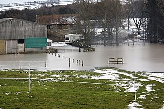
English: Flooding at Stank House Farm (#2) This photograph shows a view of some of the recent flooding that has taken place at Stank House Farm near Kilton. The picture was taken (looking in an easterly direction) from the field boundary/stile on the public footpath that runs between Kilton Lane and the farm. The footpath goes through the gate in the wall near the two caravans. |
| Date | |
| Source | From geograph.org.uk |
| Author | Philip Barker |
| Attribution (required by the license) | Philip Barker / Flooding at Stank House Farm (#2) / |
| Camera location | | View this and other nearby images on: OpenStreetMap |
|---|
_-_geograph.org.uk_-_1723098.jpg¶ms=054.547737_N_-000.926220_E_globe:Earth_type:camera_source:geograph-osgb36(NZ6955717472)_heading:90.00&language=en)
| Object location | | View this and other nearby images on: OpenStreetMap |
|---|
_-_geograph.org.uk_-_1723098.jpg¶ms=054.547550_N_-000.923300_E_globe:Earth_class:object_type:object_source:geograph-osgb36(NZ69741745)_heading:90.00&language=en)
Licensing edit
_-_geograph.org.uk_-_1723098.jpg&action=edit§ion=2)

|
This image was taken from the Geograph project collection. See this photograph's page on the Geograph website for the photographer's contact details. The copyright on this image is owned by Philip Barker and is licensed for reuse under the Creative Commons Attribution-ShareAlike 2.0 license.
|
This file is licensed under the Creative Commons Attribution-Share Alike 2.0 Generic license.
Attribution: Philip Barker
- You are free:
- to share – to copy, distribute and transmit the work
- to remix – to adapt the work
- Under the following conditions:
- attribution – You must give appropriate credit, provide a link to the license, and indicate if changes were made. You may do so in any reasonable manner, but not in any way that suggests the licensor endorses you or your use.
- share alike – If you remix, transform, or build upon the material, you must distribute your contributions under the same or compatible license as the original.

|
The categories of this image need checking. You can do so here.
|
_-_geograph.org.uk_-_1723098.jpg&action=edit&withJS=MediaWiki:Catcheck.js)
File history
Click on a date/time to view the file as it appeared at that time.
| Date/Time | Thumbnail | Dimensions | User | Comment | |
|---|---|---|---|---|---|
| current | 11:40, 5 March 2011 | | 3,084 × 2,056 (2.81 MB) | GeographBot (talk | contribs) | == {{int:filedesc}} == {{Information |description={{en|1=Flooding at Stank House Farm (#2) This photograph shows a view of some of the recent flooding that has taken place at Stank House Farm near Kilton. The picture was taken (looking in an easterly dire |
You cannot overwrite this file.
File usage on Commons
There are no pages that use this file.
_-_geograph.org.uk_-_1723098.jpg&oldid=717018512)