File:Floridsdorf - Kirche, Pius-Parsch-Platz.JPG

Size of this preview: 421 × 599 pixels. Other resolutions: 169 × 240 pixels | 337 × 480 pixels | 540 × 768 pixels | 720 × 1,024 pixels | 1,440 × 2,048 pixels | 2,741 × 3,898 pixels.
Original file (2,741 × 3,898 pixels, file size: 7.78 MB, MIME type: image/jpeg)
Captions
Captions
Add a one-line explanation of what this file represents
Summary edit
| Description |
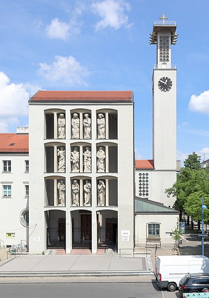
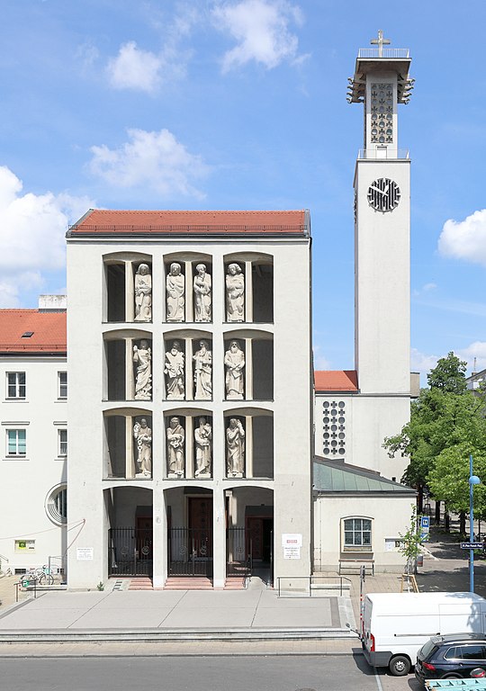
Deutsch: Die römisch-katholische Pfarrkirche hl. Josef in Floridsdorf, ein Stadtteil der österreichischen Bundeshauptstadt Wien.
Der Stahlbetonbau wurde nach den Plänen des Architekten Robert Kramreiter ab 1936 errichtet (Grundsteinlegung am 20. September), am 19. Dezember 1937 erfolgte die Benediktion (Segnung) und erst 1958 fand die feierliche Konsekration (Weihe) durch Weihbischof Dr. Josef Streidt statt. Während des Zweiten Weltkrieges wurde der Sakralbau schwer beschädigt, jedoch wieder aufgebaut und 1955 im Inneren vollständig renoviert. Von 1983 bis 1985 wurde die Kirche generalsaniert (Weihe des Volksaltars am 12. Oktober 1986): [1]. Die je vier Apostel-Sandsteinfiguren auf drei Stockwerken stammen von den Bildhauern Robert Ullmann, Franz Zorn und Franz Santifaller (Jakobus d. J., Simon, Judas Thaddäus und Thomas). English: Parish church "St. Josef" in Floridsdorf (Vienna).
|
| Date | |
| Source | Own work |
| Author | C.Stadler/Bwag |
| Permission (Reusing this file) |
Deutsch: Hallo, du darfst mein Foto kostenlos nutzen, aber nenne mich bitte als Fotograf, beispielsweise „Foto: C.Stadler/Bwag“ oder © C.Stadler/Bwag; CC-BY-SA-4.0. Auf mehr Angaben bestehe ich nicht - im Gegensatz zu manch anderen, die die Vorgaben der unten angeführten Lizenzierung auf Punkt und Beistrich einfordern. English: Feel free to use my photos, but please mention me as the author like © C.Stadler/Bwag or © C.Stadler/Bwag; CC-BY-SA-4.0 (that's good enough) and if you want send me a message: bwag@gmx.net. |
| Object location | | View this and other nearby images on: OpenStreetMap |
|---|
| Camera location | | View this and other nearby images on: OpenStreetMap |
|---|
Licensing edit
I, the copyright holder of this work, hereby publish it under the following license:
This file is licensed under the Creative Commons Attribution-Share Alike 4.0 International license.
- You are free:
- to share – to copy, distribute and transmit the work
- to remix – to adapt the work
- Under the following conditions:
- attribution – You must give appropriate credit, provide a link to the license, and indicate if changes were made. You may do so in any reasonable manner, but not in any way that suggests the licensor endorses you or your use.
- share alike – If you remix, transform, or build upon the material, you must distribute your contributions under the same or compatible license as the original.
File history
Click on a date/time to view the file as it appeared at that time.
| Date/Time | Thumbnail | Dimensions | User | Comment | |
|---|---|---|---|---|---|
| current | 16:53, 16 May 2017 | | 2,741 × 3,898 (7.78 MB) | Bwag (talk | contribs) | n |
| 06:52, 24 July 2016 |  | 2,667 × 2,755 (5.53 MB) | Bwag (talk | contribs) | wb | |
| 22:51, 13 October 2013 |  | 2,694 × 3,150 (6.45 MB) | Bwag (talk | contribs) | m | |
| 20:06, 13 October 2013 |  | 2,956 × 3,150 (7.14 MB) | Bwag (talk | contribs) | {{Information |Description= {{de|1= Die römisch-katholische Pfarrkirche hl. Josef in Floridsdorf, ein Stadtteil der österreichischen Bundeshauptstadt Wien. Die Kirche wurde nach den Plänen des Architekte... |
You cannot overwrite this file.
File usage on Commons
The following page uses this file:
File usage on other wikis
The following other wikis use this file:
- Usage on de.wikipedia.org
- Robert Kramreiter
- Pfarrkirche Donaufeld
- Pfarrkirche Gartenstadt
- Islamisches Zentrum Wien
- Liste der Pfarren im Stadtdekanat 21 (Erzdiözese Wien)
- Pfarrkirche Jedlesee
- Pfarrkirche Schwarzlackenau
- Pfarrkirche Cyrill und Method (Floridsdorf)
- Pfarrkirche Strebersdorf
- Katholische Pfarrkirche Floridsdorf
- Pfarrkirche Leopoldau
- Pfarrkirche Don Bosco (Großfeldsiedlung)
- Pfarrkirche Nordrandsiedlung
- Pfarrkirche Großjedlersdorf
- Kirche Siemensstraße
- Seelsorgestation St. Michael
- Pfarrkirche Herz Jesu (Wien-Floridsdorf)
- Pfarrkirche Stammersdorf
- Synagoge Floridsdorf
- Evangelische Pfarrkirche Floridsdorf
- Pfarrkirche Bruckhaufen
- Heilig-Kreuz-Kirche (Großfeldsiedlung)
- St. Josef der Arbeiter (Wien)
- Pfarrkirche St. Markus (Wien)
- Klosterkirche Maria Immaculata (Wien)
- Vorlage:Navigationsleiste Sakralbauten in Floridsdorf
- Erlöserkirche (Leopoldau)
- Benutzer:Dschn/Liste der Sakralbauten in Wien
- Wikipedia:WikiProjekt Österreich/WD/Floridsdorf
- Wikipedia:WikiProjekt Österreich/checks/Denkmalschutz/WP - WD diffs 07
- Usage on www.wikidata.org