File:Flugverkehr aus Deutschland mit dem Ausland.png

Size of this preview: 625 × 600 pixels. Other resolutions: 250 × 240 pixels | 500 × 480 pixels | 801 × 768 pixels | 1,068 × 1,024 pixels | 2,500 × 2,398 pixels.
Original file (2,500 × 2,398 pixels, file size: 1.74 MB, MIME type: image/png)
Captions
Captions
Add a one-line explanation of what this file represents
Summary edit
| Title |
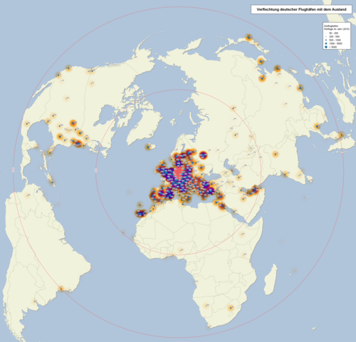
Deutsch: Karte des Flugverkehrs aus Deutschland mit dem Ausland (ab 50 Flüge pro Jahr) 2015
English: Map of commercial flights from Germany abroad (more than 50 flights per year) 2015 |
| Map legend |
Deutsch: Die roten Kreise markieren die Entfernung von Deutschland (5000 und 10000 km). Von Orange zu Violet ist eine Heatmap dargestellt, welche die Zahl der Flüge an dem betreffenden Zielflughafen visualisiert. |
| Date | |
| Source |
own work, using
|
| Creator | |
| Geotemporal data | |
| Map location | Earth |
| Spatial reference system | Azimuthal Equidistant (+proj=aeqd +lat_0=52 +lon_12=0) |
Licensing edit
I, the copyright holder of this work, hereby publish it under the following license:
This file is licensed under the Creative Commons Attribution-Share Alike 3.0 Unported license.
- You are free:
- to share – to copy, distribute and transmit the work
- to remix – to adapt the work
- Under the following conditions:
- attribution – You must give appropriate credit, provide a link to the license, and indicate if changes were made. You may do so in any reasonable manner, but not in any way that suggests the licensor endorses you or your use.
- share alike – If you remix, transform, or build upon the material, you must distribute your contributions under the same or compatible license as the original.
File history
Click on a date/time to view the file as it appeared at that time.
| Date/Time | Thumbnail | Dimensions | User | Comment | |
|---|---|---|---|---|---|
| current | 19:21, 3 October 2016 | | 2,500 × 2,398 (1.74 MB) | Alexrk2 (talk | contribs) | == {{int:description}} == {{Map |title={{de|1=Karte des Flugverkehrs aus Deutschland mit dem Ausland (ab 50 Flüge pro Jahr) 2015}} {{en|1=Map of commercial flights from Germany abroad (more than 50 flights per year) 2015}} |description= |legend= |auth... |
You cannot overwrite this file.
File usage on Commons
The following 4 pages use this file:
File usage on other wikis
The following other wikis use this file:
- Usage on de.wikipedia.org
- Usage on de.wikivoyage.org