File:Flugverkehr innerdeutsche Strecken.svg

Size of this PNG preview of this SVG file: 494 × 599 pixels. Other resolutions: 198 × 240 pixels | 396 × 480 pixels | 633 × 768 pixels | 844 × 1,024 pixels | 1,689 × 2,048 pixels | 621 × 753 pixels.
Original file (SVG file, nominally 621 × 753 pixels, file size: 1.91 MB)
Captions
Captions
Add a one-line explanation of what this file represents
Summary edit
| Title |
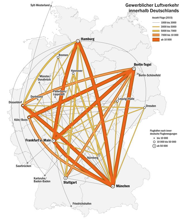
Deutsch: Karte des innerdeutschen Flugverkehrs (ab 1000 Flüge pro Jahr)
English: Map of inner German commercial flights (more than 1000 flights per year) |
| Date | |
| Source |
own work, using
|
| Creator | |
| Geotemporal data | |
| Map location | Germany |
| SVG development | |
Licensing edit
I, the copyright holder of this work, hereby publish it under the following license:
This file is licensed under the Creative Commons Attribution-Share Alike 3.0 Unported license.
- You are free:
- to share – to copy, distribute and transmit the work
- to remix – to adapt the work
- Under the following conditions:
- attribution – You must give appropriate credit, provide a link to the license, and indicate if changes were made. You may do so in any reasonable manner, but not in any way that suggests the licensor endorses you or your use.
- share alike – If you remix, transform, or build upon the material, you must distribute your contributions under the same or compatible license as the original.
File history
Click on a date/time to view the file as it appeared at that time.
| Date/Time | Thumbnail | Dimensions | User | Comment | |
|---|---|---|---|---|---|
| current | 17:19, 1 October 2016 | | 621 × 753 (1.91 MB) | Alexrk2 (talk | contribs) | - |
| 15:13, 30 September 2016 |  | 621 × 753 (1.91 MB) | Alexrk2 (talk | contribs) | minor fixes | |
| 16:51, 26 September 2016 |  | 621 × 753 (1.88 MB) | Alexrk2 (talk | contribs) | == {{int:description}} == {{Map |title={{de|1=Karte des innerdeutschen Flugverkehrs}} {{en|1=Map of inner German commercial Flights}} |description= |legend= |author=Alexrk2 |date=2016-09 |source=own work, using * [https://www.d... |
You cannot overwrite this file.
File usage on Commons
The following 9 pages use this file:
- User:Chumwa/OgreBot/Potential transport maps/2016 October 1-10
- User:Chumwa/OgreBot/Potential transport maps/2016 September 21-30
- User:Chumwa/OgreBot/Transport Maps/2016 October 1-10
- User:Chumwa/OgreBot/Transport Maps/2016 September 21-30
- User:Chumwa/OgreBot/Travel and communication maps/2016 October 1-10
- User:Chumwa/OgreBot/Travel and communication maps/2016 September 21-30
- Commons:WikiProject Aviation/recent uploads/2016 October 1
- Commons:WikiProject Aviation/recent uploads/2016 September 26
- Commons:WikiProject Aviation/recent uploads/2016 September 30
File usage on other wikis
The following other wikis use this file:
- Usage on de.wikipedia.org
- Usage on en.wikipedia.org
- Usage on fr.wikipedia.org
- Usage on pt.wikipedia.org