File:Former Hawarden bowling green - geograph.org.uk - 1496909.jpg
No higher resolution available.
Former_Hawarden_bowling_green_-_geograph.org.uk_-_1496909.jpg (640 × 480 pixels, file size: 214 KB, MIME type: image/jpeg)
Captions
Captions
Add a one-line explanation of what this file represents
Summary edit
| Description |
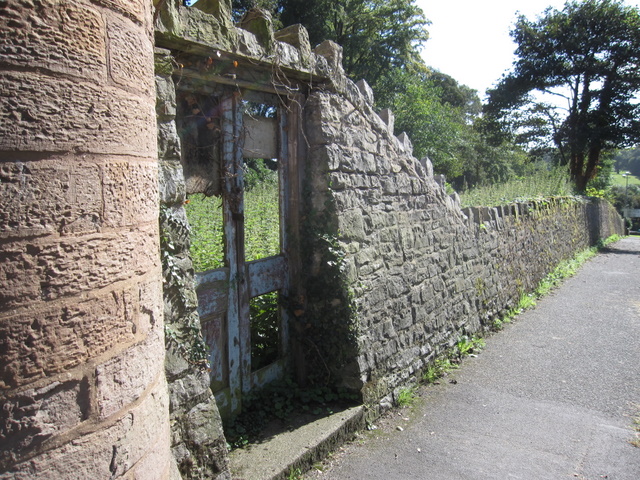
English: Former Hawarden bowling green This derelict piece of land behind the wall, near the castle gates in Hawarden, is recorded as a bowling green on the 1881 O.S. map. However, the website of the Gladstone Bowling Club states that it was used as tennis courts prior to 1939; clearly it hasn't been used for anything recently. The Gladstone Bowling Club has an interesting history and now plays on a green at the Gladstone Playing Fields, Hawarden. http://www.gladstonebowling.com/ |
| Date | |
| Source | From geograph.org.uk |
| Author | John S Turner |
| Attribution (required by the license) | John S Turner / Former Hawarden bowling green / |
| Camera location | | View this and other nearby images on: OpenStreetMap |
|---|
_heading:180.00&language=en)
| Object location | | View this and other nearby images on: OpenStreetMap |
|---|
_heading:180.00&language=en)
Licensing edit

|
This image was taken from the Geograph project collection. See this photograph's page on the Geograph website for the photographer's contact details. The copyright on this image is owned by John S Turner and is licensed for reuse under the Creative Commons Attribution-ShareAlike 2.0 license.
|
This file is licensed under the Creative Commons Attribution-Share Alike 2.0 Generic license.
Attribution: John S Turner
- You are free:
- to share – to copy, distribute and transmit the work
- to remix – to adapt the work
- Under the following conditions:
- attribution – You must give appropriate credit, provide a link to the license, and indicate if changes were made. You may do so in any reasonable manner, but not in any way that suggests the licensor endorses you or your use.
- share alike – If you remix, transform, or build upon the material, you must distribute your contributions under the same or compatible license as the original.

|
The categories of this image need checking. You can do so here.
|
File history
Click on a date/time to view the file as it appeared at that time.
| Date/Time | Thumbnail | Dimensions | User | Comment | |
|---|---|---|---|---|---|
| current | 17:17, 2 March 2011 | | 640 × 480 (214 KB) | GeographBot (talk | contribs) | == {{int:filedesc}} == {{Information |description={{en|1=Former Hawarden bowling green This derelict piece of land behind the wall, near the castle gates in Hawarden, is recorded as a bowling green on the 1881 O.S. map. However, the website of the Gladsto |
You cannot overwrite this file.
File usage on Commons
There are no pages that use this file.