File:Forrest Highway map.png
Forrest_Highway_map.png (800 × 600 pixels, file size: 50 KB, MIME type: image/png)
Captions
Captions
Summary edit
| Description |
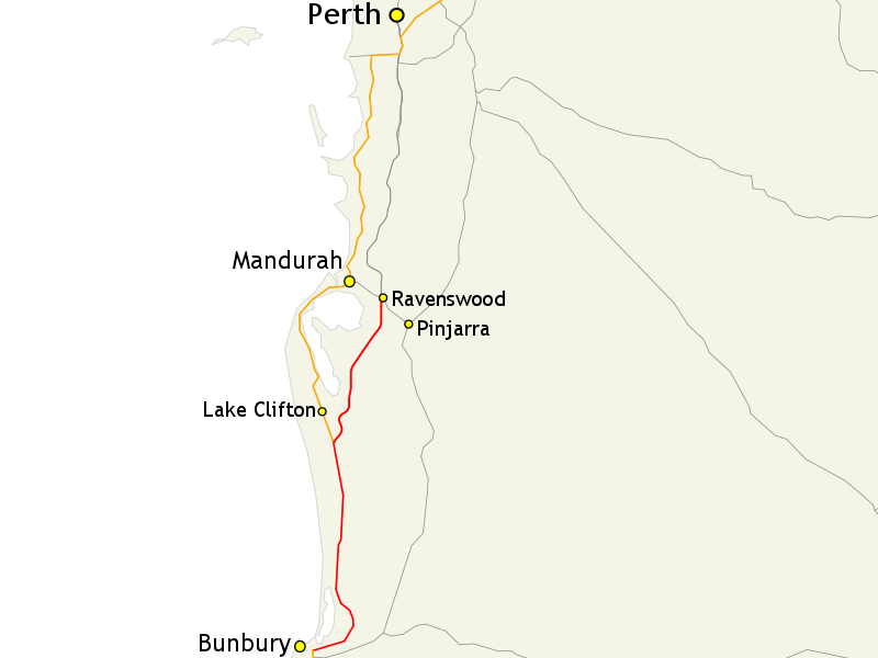
English: Map of Forrest Highway (shown in red) and surrounding road network south of Perth, Western Australia |
| Date | |
| Source |
Own work; |
| Author |
Evad37 |
| Permission (Reusing this file) |
GIS data: "Save for the content on this website supplied by third parties, the Geoscience Australia logo, the Commonwealth Coat of Arms, and any material protected by a trade mark, Geoscience Australia has applied the Creative Commons Attribution 3.0 Australia licence. Geoscience Australia asserts the right to be recognised as author of the original material in the following manner: |
| Other versions |
English: Alternate version with route markers (on the English Wikipedia) |
Map created using map data from Geoscience Australia, licensed under the Creative Commons Attribution 3.0 Australia license (CC BY 3.0 AU).
Licensing edit
- You are free:
- to share – to copy, distribute and transmit the work
- to remix – to adapt the work
- Under the following conditions:
- attribution – You must give appropriate credit, provide a link to the license, and indicate if changes were made. You may do so in any reasonable manner, but not in any way that suggests the licensor endorses you or your use.
- share alike – If you remix, transform, or build upon the material, you must distribute your contributions under the same or compatible license as the original.
File history
Click on a date/time to view the file as it appeared at that time.
| Date/Time | Thumbnail | Dimensions | User | Comment | |
|---|---|---|---|---|---|
| current | 06:42, 29 June 2014 | | 800 × 600 (50 KB) | Evad37 (talk | contribs) | Route extended to Bunbury |
| 08:44, 23 September 2013 |  | 800 × 600 (50 KB) | Evad37 (talk | contribs) | Removed route markers - see w:en:File:Forrest Highway route map.png for version with route markers | |
| 16:36, 13 July 2013 |  | 800 × 600 (59 KB) | Evad37 (talk | contribs) | User created page with UploadWizard |
You cannot overwrite this file.
File usage on Commons
The following page uses this file:
File usage on other wikis
The following other wikis use this file:
- Usage on www.wikidata.org