File:Fort Raleigh National Historic Site LOC 80695127.tif

Size of this JPG preview of this TIF file: 800 × 460 pixels. Other resolutions: 320 × 184 pixels | 640 × 368 pixels | 1,024 × 589 pixels | 1,280 × 737 pixels | 2,560 × 1,473 pixels | 6,000 × 3,453 pixels.
Original file (6,000 × 3,453 pixels, file size: 59.27 MB, MIME type: image/tiff)
Captions
Captions
Add a one-line explanation of what this file represents
Summary edit
| Description |
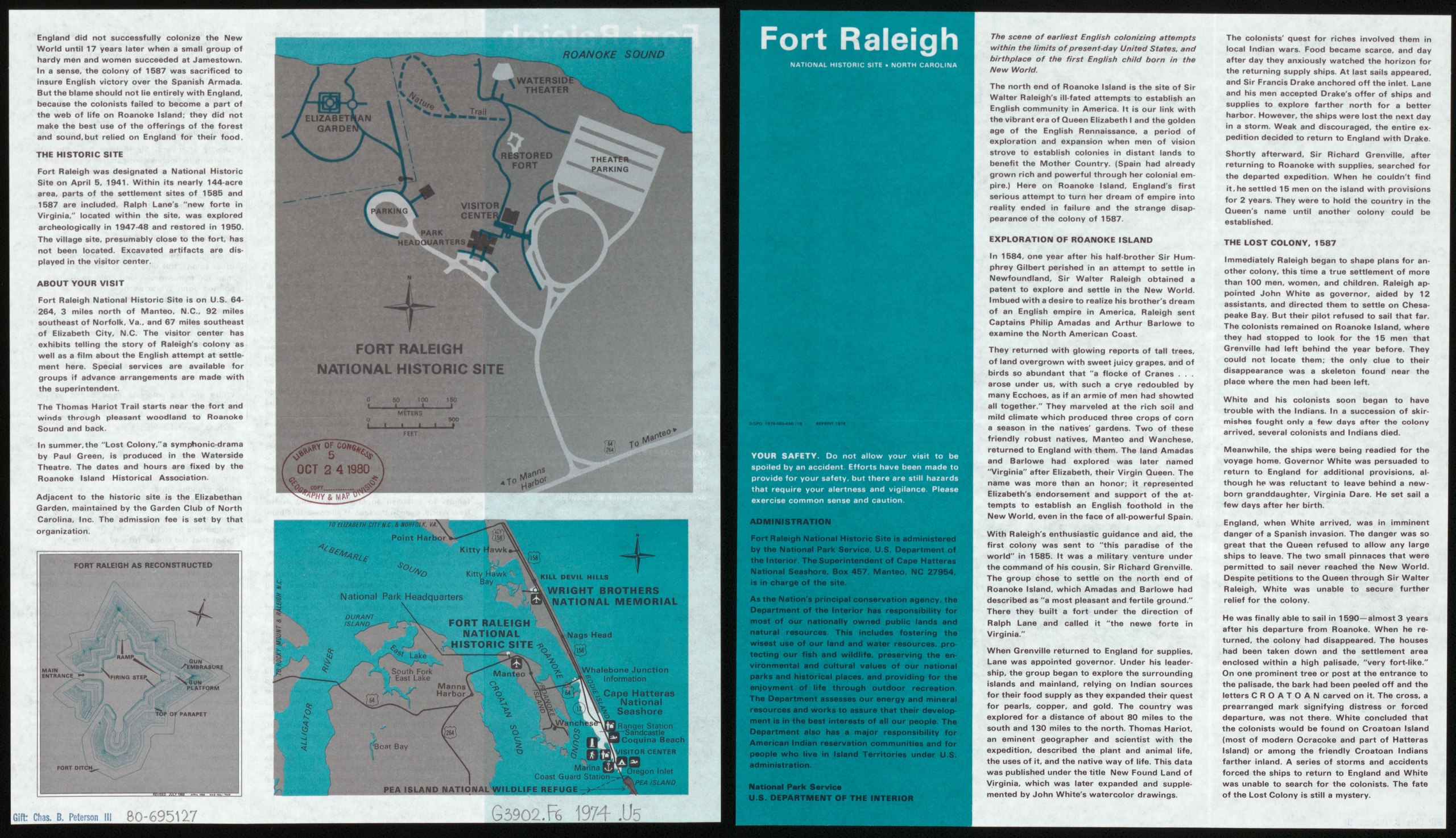
English: Scale ca. 1:5,000. Folded title: Fort Raleigh National Historic Site, North Carolina. Includes text, map of "Fort Raleigh as reconstructed," and location map. Text on verso. Available also through the Library of Congress Web site as a raster image. AACR2 |
||
| Title | Fort Raleigh National Historic Site | ||
| Shelf ID | G3902.F6 1974 .U5 | ||
| Date | |||
| Source | https://www.loc.gov/item/80695127/ | ||
| Author | United States. National Park Service | ||
| Permission (Reusing this file) |
|
||
| Other versions |
|
||
| Location | United States · North Carolina · Fort Raleigh National Historic Site | ||
| Part of | American Memory · General Maps · Catalog · Geography And Map Division | ||
| Subject | United States · Maps · Fort Raleigh National Historic Site · Fort Raleigh National Historic Site (N.C.) · North Carolina |


Licensing edit
| This image or media file contains material based on a work of a National Park Service employee, created as part of that person's official duties. As a work of the U.S. federal government, such work is in the public domain in the United States. See the NPS website and NPS copyright policy for more information. |
File history
Click on a date/time to view the file as it appeared at that time.
| Date/Time | Thumbnail | Dimensions | User | Comment | |
|---|---|---|---|---|---|
| current | 12:30, 7 June 2018 |  | 6,000 × 3,453 (59.27 MB) | Fæ (talk | contribs) | LOC Maps https://www.loc.gov/item/80695127/ #7532 |
You cannot overwrite this file.
File usage on Commons
The following page uses this file: