File:Fotothek df pk 0000032 039 Sommer 1947.jpg
Size of this preview: 396 × 599 pixels. Other resolutions: 158 × 240 pixels | 510 × 772 pixels.
Original file (510 × 772 pixels, file size: 162 KB, MIME type: image/jpeg)
Captions
Captions
Add a one-line explanation of what this file represents
Summary edit
| Bansin und Wannsee
( |
|||||||||||||||||||||||||||
|---|---|---|---|---|---|---|---|---|---|---|---|---|---|---|---|---|---|---|---|---|---|---|---|---|---|---|---|
| Photographer |
|
||||||||||||||||||||||||||
| Title |
Bansin und Wannsee |
||||||||||||||||||||||||||
| Original caption |
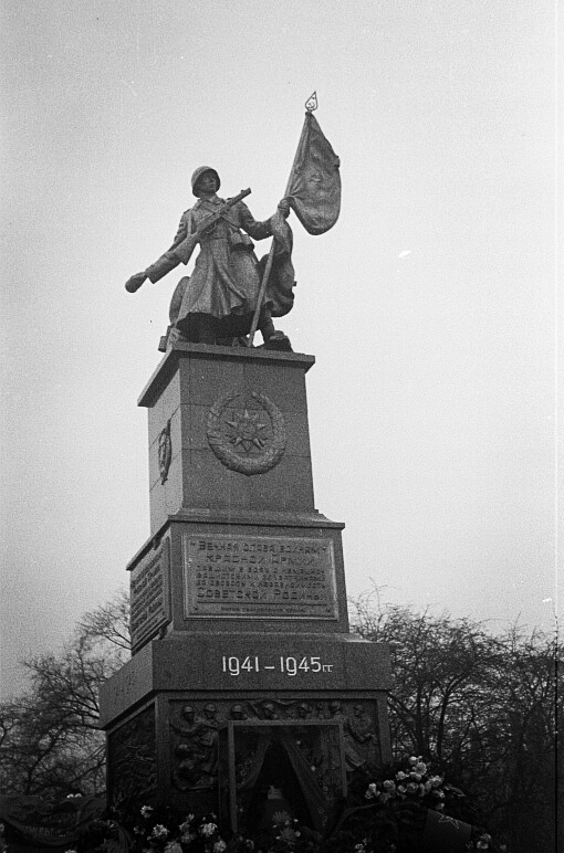
Original image description from the Deutsche Fotothek Denkmal der Roten Armee von Otto Rost (geschaffen 1945) ehemaliger Standort ist der heutige Albertplatz / Dresden-Neustadt, Sommer 1947 |
||||||||||||||||||||||||||
| Depicted place | Bansin & Wannsee | ||||||||||||||||||||||||||
| Date | 1947 | ||||||||||||||||||||||||||
| Collection |
|
||||||||||||||||||||||||||
| Accession number | |||||||||||||||||||||||||||
| Source | Deutsche Fotothek | ||||||||||||||||||||||||||
| Detailed information from the Deutsche Fotothek | |
|---|---|
| Leading tag for repeatable field group „Foto“ | Foto |
| Owner of the photograph | Deutsche Fotothek |
| Image file name | df_pk_0000032_039 |
| Photograph | Pisarek, Abraham |
| Record ID | 88930330 |
| Title | Bansin und Wannsee |
| Dating | 1947 |
| Reproduced location / repeatable field group | Bansin & Wannsee |
| Sachbegriff/category | Foto |
| Image description | Denkmal der Roten Armee von Otto Rost (geschaffen 1945) ehemaliger Standort ist der heutige Albertplatz / Dresden-Neustadt, Sommer 1947 |
| Author of the data record | Deutsche Fotothek, gefördert von den Kulturstiftungen des Bundes und der Länder (KUR-Projekt) |
| Object location | | View this and other nearby images on: OpenStreetMap |
|---|
Licensing edit
This file was provided to Wikimedia Commons by the Deutsche Fotothek of the Saxon State Library / State and University Library Dresden (SLUB) as part of a cooperation project. The Deutsche Fotothek guarantees an authentic representation only by using copies of the original images as provided by the Digital Image Archive.
|
This file is licensed under the Creative Commons Attribution-Share Alike 3.0 Germany license.
Attribution: Deutsche Fotothek
- You are free:
- to share – to copy, distribute and transmit the work
- to remix – to adapt the work
- Under the following conditions:
- attribution – You must give appropriate credit, provide a link to the license, and indicate if changes were made. You may do so in any reasonable manner, but not in any way that suggests the licensor endorses you or your use.
- share alike – If you remix, transform, or build upon the material, you must distribute your contributions under the same or compatible license as the original.

| Camera location | | View this and other nearby images on: OpenStreetMap |
|---|
File history
Click on a date/time to view the file as it appeared at that time.
| Date/Time | Thumbnail | Dimensions | User | Comment | |
|---|---|---|---|---|---|
| current | 08:26, 21 January 2020 | | 510 × 772 (162 KB) | 1970gemini (talk | contribs) | entschleiert |
| 07:01, 4 January 2018 |  | 510 × 772 (111 KB) | Xgeorg (talk | contribs) | Cropped 4 % horizontally and 6 % vertically using CropTool with lossless mode. | |
| 12:38, 16 April 2009 |  | 529 × 820 (117 KB) | FotothekBot (talk | contribs) | {{Fotothek-Description | description = <!-- To override the description field --> | comment = <!-- To add a comment --> | date = <!-- To override the date field --> | author = <!-- To override the author field --> | 8450_1 = Foto | 8450_1_8460 = Deutsche |
You cannot overwrite this file.
File usage on Commons
The following 7 pages use this file:
- User:Derbrauni/NeuesDresden/2018 January 1-10
- User:Derbrauni/NeuesDresden/2020 January 21-31
- User:Frze/Category:Dresden uploads/2018 January 1-10
- User:Frze/Category:Dresden uploads/2020 January 21-31
- User:Sanandros/ogre/firearms/2018 January 1-10
- User:Sanandros/ogre/firearms/2020 January 21-31
- File:Fotothek df pk 0000032 039 Sommer 1947.jpg
File usage on other wikis
The following other wikis use this file:
- Usage on de.wikipedia.org