File:France drainage basins.svg

Size of this PNG preview of this SVG file: 632 × 600 pixels. Other resolutions: 253 × 240 pixels | 506 × 480 pixels | 809 × 768 pixels | 1,079 × 1,024 pixels | 2,158 × 2,048 pixels | 2,000 × 1,898 pixels.
Original file (SVG file, nominally 2,000 × 1,898 pixels, file size: 728 KB)
Captions
Captions
Add a one-line explanation of what this file represents
| Description |
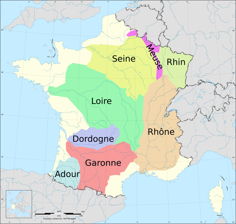
English: Drainage basins of mains rivers of France (Avg. discharge >150 m3/s) Français : Bassins versants des fleuves français possédant un début moyen >150 m3/s Lambert-93 projection ; RGF-93 datum Scale: 1:2,000,000 |
| Date | (UTC) |
| Source | |
| Author |
|
| Other versions |
|

I, the copyright holder of this work, hereby publish it under the following licenses:
This file is licensed under the Creative Commons Attribution-Share Alike 3.0 Unported, 2.5 Generic, 2.0 Generic and 1.0 Generic license.
- You are free:
- to share – to copy, distribute and transmit the work
- to remix – to adapt the work
- Under the following conditions:
- attribution – You must give appropriate credit, provide a link to the license, and indicate if changes were made. You may do so in any reasonable manner, but not in any way that suggests the licensor endorses you or your use.
- share alike – If you remix, transform, or build upon the material, you must distribute your contributions under the same or compatible license as the original.

|
Permission is granted to copy, distribute and/or modify this document under the terms of the GNU Free Documentation License, Version 1.2 or any later version published by the Free Software Foundation; with no Invariant Sections, no Front-Cover Texts, and no Back-Cover Texts. A copy of the license is included in the section entitled GNU Free Documentation License. |
You may select the license of your choice.
Original upload log
edit
This image is a derivative work of the following images:
- File:France_map_Lambert-93_with_rivers-blank.svg licensed with Cc-by-sa-3.0,2.5,2.0,1.0, GFDL
- 2008-11-13T17:40:30Z Sting 2000x1898 (901649 Bytes) + boundary for Channel Islands ; - canals
- 2008-10-01T04:35:28Z Sting 2000x1898 (875598 Bytes) == Summary == {{Location|46|15|00|N|02|06|00|E|scale:10000000}} {{Information |Description={{en|Blank map of [[:en:France|France]] in the official Lambert-93 projection, with rivers.}} {{fr|Carte vierge de la [[:fr:France|Fr
Uploaded with derivativeFX
File history
Click on a date/time to view the file as it appeared at that time.
| Date/Time | Thumbnail | Dimensions | User | Comment | |
|---|---|---|---|---|---|
| current | 12:06, 21 September 2010 | | 2,000 × 1,898 (728 KB) | Ske (talk | contribs) | s/Gironde/Garonne |
| 12:00, 21 September 2010 |  | 2,000 × 1,898 (728 KB) | Ske (talk | contribs) | fix | |
| 11:56, 21 September 2010 |  | 2,000 × 1,898 (728 KB) | Ske (talk | contribs) | {{Information |Description={{en|Drainage basins of mains rivers of France (Avg. discharge >150 m3/s)}} {{fr|Bassins versants des fleuves français possédant un début moyen >150 m3/s}}<br/> Lambert-93 projection ; RGF-93 datum<br/> Scale: 1:2,000,000 | |
You cannot overwrite this file.
File usage on Commons
The following page uses this file:
File usage on other wikis
The following other wikis use this file:
- Usage on ca.wikipedia.org
- Usage on da.wikipedia.org
- Usage on eo.wikipedia.org
- Usage on fr.wikipedia.org
- Usage on hy.wikipedia.org
- Usage on pms.wikipedia.org
- Usage on ru.wikipedia.org
- Usage on uk.wikipedia.org