File:France location map-Departements 1815.svg

Size of this PNG preview of this SVG file: 624 × 600 pixels. Other resolutions: 250 × 240 pixels | 499 × 480 pixels | 799 × 768 pixels | 1,066 × 1,024 pixels | 2,131 × 2,048 pixels | 2,000 × 1,922 pixels.
Original file (SVG file, nominally 2,000 × 1,922 pixels, file size: 588 KB)
Captions
Captions
Add a one-line explanation of what this file represents
Summary edit
| Description |
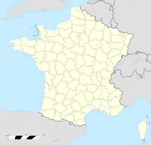
English: Map of Departments of France in 1815. Français : Carte des Départements français en 1815. |
| Date | |
| Source |
|
| Author | Flappiefh |
| Other versions |
[]
|
| SVG | W3C-validity not checked. |
| Graphic Lab |


| Object location | | View this and other nearby images on: OpenStreetMap |
|---|
Licensing edit
I, the copyright holder of this work, hereby publish it under the following license:
This file is licensed under the Creative Commons Attribution-Share Alike 4.0 International license.
- You are free:
- to share – to copy, distribute and transmit the work
- to remix – to adapt the work
- Under the following conditions:
- attribution – You must give appropriate credit, provide a link to the license, and indicate if changes were made. You may do so in any reasonable manner, but not in any way that suggests the licensor endorses you or your use.
- share alike – If you remix, transform, or build upon the material, you must distribute your contributions under the same or compatible license as the original.
File history
Click on a date/time to view the file as it appeared at that time.
| Date/Time | Thumbnail | Dimensions | User | Comment | |
|---|---|---|---|---|---|
| current | 21:40, 7 May 2015 | | 2,000 × 1,922 (588 KB) | Flappiefh (talk | contribs) | Fixed Rhône and Isère borders. |
| 07:53, 7 May 2015 |  | 2,000 × 1,922 (580 KB) | Flappiefh (talk | contribs) | User created page with UploadWizard |
You cannot overwrite this file.
File usage on Commons
The following 32 pages use this file:
- User:JsfasdF252/sandbox
- File:France location map-Departements 1790.svg
- File:France location map-Departements 1791.svg
- File:France location map-Departements 1793.svg
- File:France location map-Departements 1795.svg
- File:France location map-Departements 1797.svg
- File:France location map-Departements 1798.svg
- File:France location map-Departements 1800.svg
- File:France location map-Departements 1801.svg
- File:France location map-Departements 1802.svg
- File:France location map-Departements 1805.svg
- File:France location map-Departements 1808.svg
- File:France location map-Departements 1810.svg
- File:France location map-Departements 1811.svg
- File:France location map-Departements 1812.svg
- File:France location map-Departements 1813.svg
- File:France location map-Departements 1814.svg
- File:France location map-Departements 1815.svg
- File:France location map-Departements 1848.svg
- File:France location map-Departements 1852.svg
- File:France location map-Departements 1860.svg
- File:France location map-Departements 1871-1914.svg
- File:France location map-Departements 1919.svg
- File:France location map-Departements 1947.svg
- File:France location map-Departements 1964.svg
- File:France location map-Departements 1967.svg
- File:France location map-Departements 1970.svg
- File:France location map-Departements 1971-1972.svg
- File:France location map-Departements 1973-1974.svg
- File:France location map-Departements 1975-1996.svg
- File:France location map-Provinces 1789.svg
- Template:Other versions/France location map-Departements
File usage on other wikis
The following other wikis use this file:
- Usage on fr.wikipedia.org