File:Francio06-mapo.JPG
Size of this preview: 533 × 599 pixels. Other resolutions: 213 × 240 pixels | 427 × 480 pixels | 990 × 1,113 pixels.
Original file (990 × 1,113 pixels, file size: 352 KB, MIME type: image/jpeg)
Captions
Captions
Add a one-line explanation of what this file represents
Summary edit
| Description |
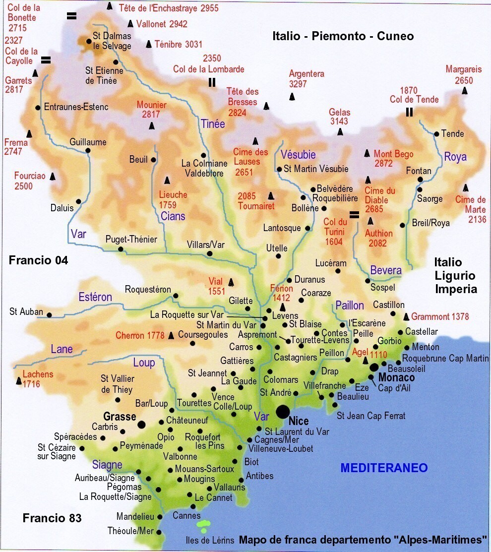
Esperanto: Mapo de la franca departemento de "Alpes-Maritimes" (n°06, "ĉemaraj alpoj"), kiun verkis S-ro Eric Coffinet.
|
| Date | 18 January 2007 (original upload date) |
| Source | Transferred from eo.wikipedia to Commons. |
| Author | Eric.Coffinet at Esperanto Wikipedia |
Licensing edit
| I, the copyright holder of this work, release this work into the public domain. This applies worldwide. In some countries this may not be legally possible; if so: I grant anyone the right to use this work for any purpose, without any conditions, unless such conditions are required by law. |
Original upload log edit
The original description page was here. All following user names refer to eo.wikipedia.
| Date/Time | Dimensions | User | Comment |
|---|---|---|---|
| 2007-01-24 12:53 | 990×1113× (360413 bytes) | Eric.Coffinet | |
| 2007-01-23 13:57 | 622×615× (122465 bytes) | Eric.Coffinet | |
| 2007-01-23 10:08 | 622×615× (140619 bytes) | Eric.Coffinet | Mapo de la franca departemento de "Alpes-Maritimes" (n°06, "ĉemaraj alpoj") *nigre skribitaj : landoj kaj urboj. *blue skribitaj : maro kaj riveroj. *ruĝe skribitaj : montaroj :1: ''Mont Agel'' (1110m) :2: ''Mont Férion'' (1412m) :3: ''Mont Vial'' (15 |
| 2007-01-18 10:27 | 522×516× (111730 bytes) | Eric.Coffinet | mapo de la franca departemento de "Alpes Maritimes" (n°06, "ĉemaraj alpoj") {{PD-self}} |
File history
Click on a date/time to view the file as it appeared at that time.
| Date/Time | Thumbnail | Dimensions | User | Comment | |
|---|---|---|---|---|---|
| current | 20:49, 7 May 2016 | | 990 × 1,113 (352 KB) | NMaia (talk | contribs) | Transferred from eo.wikipedia |
You cannot overwrite this file.
File usage on Commons
There are no pages that use this file.
File usage on other wikis
The following other wikis use this file:
- Usage on eo.wikipedia.org
- Usage on fr.wikipedia.org