File:Francisco Coello (1853 segunda edición) mapa de la provincia de Madrid.pdf

No higher resolution available.
Francisco_Coello_(1853_segunda_edición)_mapa_de_la_provincia_de_Madrid.pdf (772 × 579 pixels, file size: 1.57 MB, MIME type: application/pdf)
Captions
Captions
Add a one-line explanation of what this file represents
Summary edit
| Description |
Español: Mapa de la provincia de Madrid (España) realizado por Francisco Coello en 1853 (2ª edición); a escala 1:200.000. Dimensiones: grabado col. 80 x 106 cm, plegado a 17 x 10 cm en carpetilla de 18 x 12 cm. Las notas estadísticas e históricas son de Pascual Madoz, el contorno realizado por Raynaud, la topografía por Camilo Alabern, y la letra por Pierre Adolphe Bacot. Se publicó en:
|
||||
| Date | |||||
| Source | Francisco Coello. Mapa de la provincia de Madrid. Atlas de España y sus posesiones de Ultramar (2ª edición). Madrid: (s.n.); 1853. | ||||
| Author | Francisco Coello | ||||
| Permission (Reusing this file) |
|
||||
| Other versions |
_mapa_de_la_Provincia_de_Madrid.png) |
||||
Licensing edit
|
This work is in the public domain in its country of origin and other countries and areas where the copyright term is the author's life plus 70 years or fewer. This work is in the public domain in the United States because it was published (or registered with the U.S. Copyright Office) before January 1, 1929. | |
| This file has been identified as being free of known restrictions under copyright law, including all related and neighboring rights. | |
Referencias edit
File history
Click on a date/time to view the file as it appeared at that time.
| Date/Time | Thumbnail | Dimensions | User | Comment | |
|---|---|---|---|---|---|
| current | 15:29, 26 March 2017 | 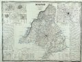 | 772 × 579 (1.57 MB) | Raimundo Pastor (talk | contribs) | User created page with UploadWizard |
You cannot overwrite this file.
File usage on Commons
The following 3 pages use this file: