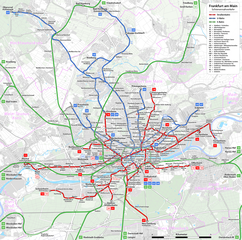
File:Frankfurt am Main - Netzplan Schienennahverkehr.png

Size of this preview: 604 × 599 pixels. Other resolutions: 242 × 240 pixels | 484 × 480 pixels | 774 × 768 pixels | 1,032 × 1,024 pixels | 2,064 × 2,048 pixels | 3,017 × 2,994 pixels.
Original file (3,017 × 2,994 pixels, file size: 5.53 MB, MIME type: image/png)
Captions
Captions
Add a one-line explanation of what this file represents
Summary edit
| Description |
|
| Date | see file history |
| Source | Own work, using OpenStreetMap data for the background |
| Author | Maximilian Dörrbecker (Chumwa) |
| Permission (Reusing this file) |
All OpenStreetMap data and maps are Creative Commons "CC-BY-SA 2.0" licensed This file is licensed under the Creative Commons Attribution-Share Alike 2.0 Generic license.
|
| Other versions |
|

.png)


| This work contains information from OpenStreetMap, which is made available under the Open Database License (ODbL).
The ODbL does not require any particular license for maps produced from ODbL data. Prior to 1 August 2020, map tiles produced by the OpenStreetMap Foundation were licensed under the CC-BY-SA-2.0 license. Maps produced by other people may be subject to other licences. |

|
This transport map image could be re-created using vector graphics as an SVG file. This has several advantages; see Commons:Media for cleanup for more information. If an SVG form of this image is available, please upload it and afterwards replace this template with
{{vector version available|new image name}}.
It is recommended to name the SVG file “Frankfurt am Main - Netzplan Schienennahverkehr.svg”—then the template Vector version available (or Vva) does not need the new image name parameter. |
File history
Click on a date/time to view the file as it appeared at that time.
| Date/Time | Thumbnail | Dimensions | User | Comment | |
|---|---|---|---|---|---|
| current | 07:12, 19 January 2019 | | 3,017 × 2,994 (5.53 MB) | Chumwa (talk | contribs) | Eisenbahnverbindungskurve nachgetragen |
| 14:01, 5 January 2019 |  | 3,017 × 2,994 (5.53 MB) | Chumwa (talk | contribs) | Streckentausch U6 ←→ U7 | |
| 16:41, 5 October 2017 |  | 3,017 × 2,994 (5.53 MB) | Chumwa (talk | contribs) | Planungen wieder herausgenommen | |
| 17:37, 4 October 2017 |  | 3,017 × 2,994 (5.53 MB) | Chumwa (talk | contribs) | Aktualisierung | |
| 04:37, 15 December 2014 |  | 3,017 × 2,994 (5.53 MB) | Chumwa (talk | contribs) | Lieschen raus, Gallus Süd nur noch Betriebsstrecke | |
| 19:55, 14 December 2014 |  | 3,017 × 2,994 (5.54 MB) | Chumwa (talk | contribs) | Fahrplanwechsel 14.12.2014 | |
| 20:03, 25 December 2011 |  | 3,017 × 2,994 (5.34 MB) | Chumwa (talk | contribs) | {{Information |Description= *{{ de }} Netzplan der Straßenbahn und U-Bahn Frankfurt am Main *{{ en }} Map of the Frankfurt tramway and metro system *{{ fr }} Plan des réseaux du tramway et de métro de Francfort-sur-le-Main |Author=[[:de:User:Chumwa|Ma |
You cannot overwrite this file.
File usage on Commons
The following 22 pages use this file:
- Straßenbahn Frankfurt am Main
- Top 200 transport map images that should use vector graphics
- Verkehr in Frankfurt am Main
- User:Chumwa/Gallery
- User:Chumwa/OgreBot/Potential transport maps/2017 October 1-10
- User:Chumwa/OgreBot/Potential transport maps/2019 January 1-10
- User:Chumwa/OgreBot/Potential transport maps/2019 January 11-20
- User:Chumwa/OgreBot/Public transport information/2017 October 1-10
- User:Chumwa/OgreBot/Public transport information/2019 January 1-10
- User:Chumwa/OgreBot/Public transport information/2019 January 11-20
- User:Chumwa/OgreBot/Transport Maps/2017 October 1-10
- User:Chumwa/OgreBot/Transport Maps/2019 January 1-10
- User:Chumwa/OgreBot/Transport Maps/2019 January 11-20
- User:Chumwa/OgreBot/Travel and communication maps/2017 October 1-10
- User:Chumwa/OgreBot/Travel and communication maps/2019 January 1-10
- User:Chumwa/OgreBot/Travel and communication maps/2019 January 11-20
- User:Clic/Nahverkehr in Deutschland/2019 January 11-20
- File:Frankfurt am Main - Netzplan Schienennahverkehr.png
- File:Frankfurt am Main - Netzplan Schienennahverkehr (einfach).png
- File:Frankfurt am Main - Streckenführung der geplanten Regionaltangente West.png
- File:Frankfurt am Main - Streckenführung der geplanten Ringstraßenbahn.png
- Category:Public transport in Frankfurt am Main
File usage on other wikis
The following other wikis use this file:
- Usage on be.wikipedia.org
- Usage on ca.wikipedia.org
- Usage on cs.wikipedia.org
- Usage on da.wikipedia.org
- Usage on de.wikipedia.org
- Frankfurt am Main
- Stadtwerke Verkehrsgesellschaft Frankfurt am Main
- Nahverkehr in Frankfurt am Main
- Benutzer:Chumwa
- Wikipedia:Kartenwerkstatt/Archiv/2012-01
- Wikipedia:Kartenwerkstatt/Karte des Tages/Galerie
- Wikipedia:Kartenwerkstatt/Archiv/2014-12
- Benutzer:Chumwa/SomeOfMyFiles
- Wikipedia:Kartenwerkstatt/Archiv/2017-10
- Wikipedia:Kartenwerkstatt/Archiv/2019-01
- Benutzer Diskussion:Chumwa/Archiv/2021/1. Quartal
- Usage on de.wikivoyage.org
- Usage on el.wikipedia.org
- Usage on en.wikipedia.org
- Usage on eo.wikipedia.org
- Usage on et.wikipedia.org
- Usage on ext.wikipedia.org
- Usage on fa.wikipedia.org
- Usage on fi.wikipedia.org
- Usage on fr.wikipedia.org
- Usage on gl.wikipedia.org
- Usage on hi.wikipedia.org
- Usage on hu.wikipedia.org
- Usage on id.wikipedia.org
- Usage on it.wikipedia.org
- Usage on ja.wikipedia.org
- Usage on ka.wikipedia.org
- Usage on kn.wikipedia.org
- Usage on la.wikipedia.org
- Usage on mk.wikipedia.org
- Usage on nl.wikipedia.org
- Usage on pt.wikipedia.org
- Usage on ru.wikipedia.org
- Usage on simple.wikipedia.org
- Usage on sk.wikipedia.org
- Usage on sv.wikipedia.org
- Usage on tr.wikipedia.org
- Usage on vi.wikipedia.org
- Usage on www.wikidata.org
- Usage on zh.wikipedia.org