File:Frankreich 12. Jh (ohne Süd).png
Size of this preview: 592 × 599 pixels. Other resolutions: 237 × 240 pixels | 474 × 480 pixels | 758 × 768 pixels | 1,011 × 1,024 pixels | 2,022 × 2,048 pixels | 2,607 × 2,640 pixels.
Original file (2,607 × 2,640 pixels, file size: 2.41 MB, MIME type: image/png)
Captions
Captions
Add a one-line explanation of what this file represents
Summary edit
.png&action=edit§ion=1)
| Description |
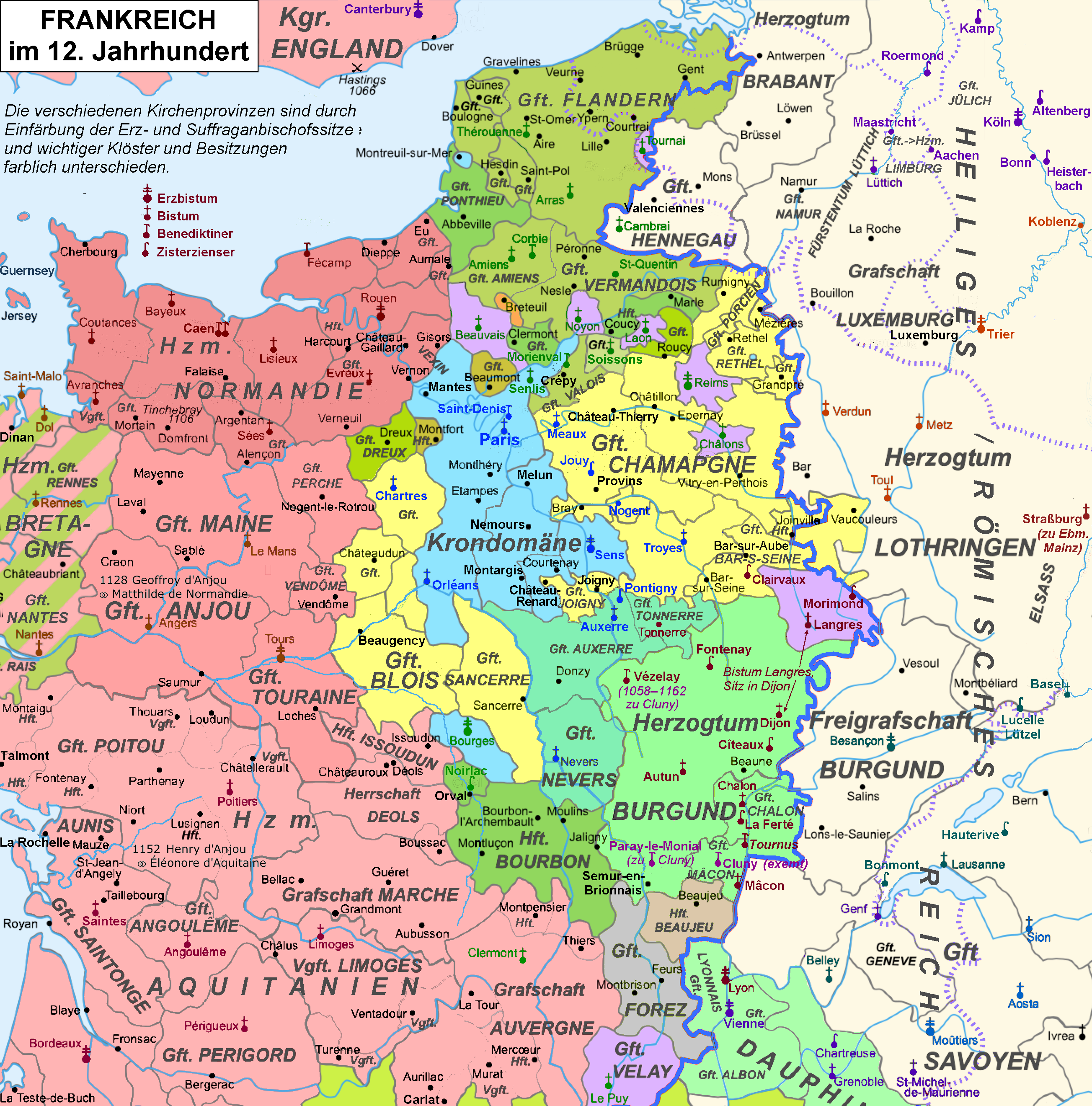
Deutsch: Pontigny zwischen Herzogtum Burgund, Grafschaft Champagne und der Krondomäne, Aussschnitt einer Karte Frankreichs im Jahr 1180
Français : La France du XUUme siècle, l'expansion angévine, la structure administrative de l'église, divers abbayes
English: France in the C XII, the angevine expansion, rhe administrative structures of the church, some monasteries |
||
| Date | (UTC) | ||
| Source | Map France 1180-fr.svg->File:Map France 1180-de.svg | ||
| Author |
Quellen/Sources:
|
||
| PNG development | This map was created with Adobe Illustrator.
|
Licensing edit
.png&action=edit§ion=2)
I, the copyright holder of this work, hereby publish it under the following licenses:

|
Permission is granted to copy, distribute and/or modify this document under the terms of the GNU Free Documentation License, Version 1.2 or any later version published by the Free Software Foundation; with no Invariant Sections, no Front-Cover Texts, and no Back-Cover Texts. A copy of the license is included in the section entitled GNU Free Documentation License. |
This file is licensed under the Creative Commons Attribution-Share Alike Attribution-Share Alike 4.0 International, 3.0 Unported, 2.5 Generic, 2.0 Generic and 1.0 Generic license.
- You are free:
- to share – to copy, distribute and transmit the work
- to remix – to adapt the work
- Under the following conditions:
- attribution – You must give appropriate credit, provide a link to the license, and indicate if changes were made. You may do so in any reasonable manner, but not in any way that suggests the licensor endorses you or your use.
- share alike – If you remix, transform, or build upon the material, you must distribute your contributions under the same or compatible license as the original.
You may select the license of your choice.
}
File history
Click on a date/time to view the file as it appeared at that time.
| Date/Time | Thumbnail | Dimensions | User | Comment | |
|---|---|---|---|---|---|
| current | 19:36, 27 August 2021 | | 2,607 × 2,640 (2.41 MB) | Ulamm (talk | contribs) | Suffraganbistümer |
| 10:44, 4 August 2021 |  | 2,607 × 2,640 (2.41 MB) | Ulamm (talk | contribs) | once more | |
| 10:37, 4 August 2021 |  | 2,607 × 2,640 (2.41 MB) | Ulamm (talk | contribs) | some more names | |
| 20:50, 3 August 2021 |  | 2,607 × 2,640 (2.43 MB) | Ulamm (talk | contribs) | one reilc of production withdrawn, and improvement of the explanation | |
| 19:02, 3 August 2021 |  | 2,607 × 2,640 (2.44 MB) | Ulamm (talk | contribs) | {{Information |Description={{de|1=Pontigny zwischen Herzogtum Burgund, Grafschaft Champagne und der Krondomäne, Aussschnitt einer Karte Frankreichs im Jahr 1180}} {{fr|1=La France du XUUme siècle, l'expansion angévine, la structure administrative de l'église, divers abbayes}} {{en|1=France in the C XII, the angevine expansion, rhe administrative structures of the church, some monasteries}} |Source={{F|Map_France_1180-fr.svg}}->File:Map France 1180-de.svg |Date=2011-12-23 23:51 (UTC) |Aut... |
You cannot overwrite this file.
File usage on Commons
There are no pages that use this file.
File usage on other wikis
The following other wikis use this file:
- Usage on de.wikipedia.org
.png&oldid=714668237)