File:Freedom in the World 2018.svg

Size of this PNG preview of this SVG file: 800 × 411 pixels. Other resolutions: 320 × 164 pixels | 640 × 329 pixels | 1,024 × 526 pixels | 1,280 × 657 pixels | 2,560 × 1,314 pixels.
Original file (SVG file, nominally 2,560 × 1,314 pixels, file size: 1.11 MB)
Captions
Captions
Add a one-line explanation of what this file represents

Summary edit
| Description |
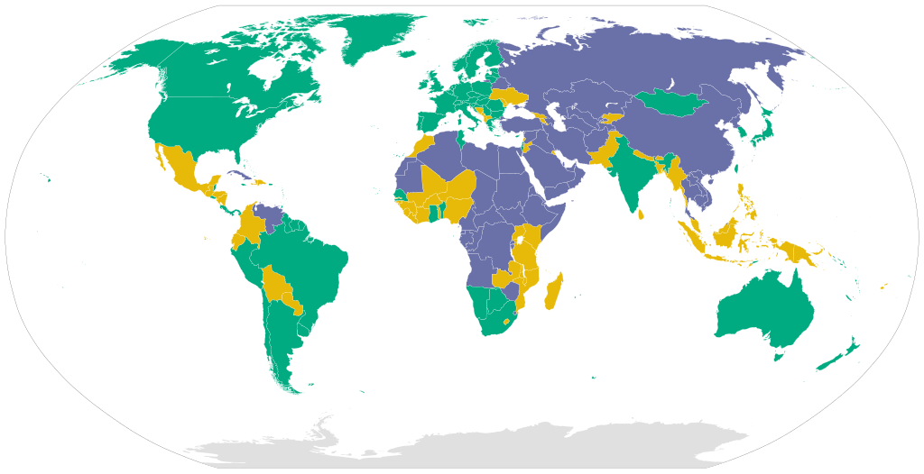
English: Classification of countries according to the Freedom in the World 2018 report by Freedom House.
Free
Partly Free
Not Free Español: Clasificación de países según el informe Libertad en el mundo 2018 de Freedom House.
Libre
Parcialmente libre
Sin libertad Српски / srpski: Klasifikacija država po Freedom House-ovom izveštaju Sloboda u svetu iz 2018. godine.
Slobodna
Delimično slobodna
Nije slobodna |
| Date | |
| Source |
This file was derived from: BlankMap-World6.svg: |
| Author |
|
Licensing edit
I, the copyright holder of this work, hereby publish it under the following license:
This file is licensed under the Creative Commons Attribution-Share Alike 4.0 International license.
- You are free:
- to share – to copy, distribute and transmit the work
- to remix – to adapt the work
- Under the following conditions:
- attribution – You must give appropriate credit, provide a link to the license, and indicate if changes were made. You may do so in any reasonable manner, but not in any way that suggests the licensor endorses you or your use.
- share alike – If you remix, transform, or build upon the material, you must distribute your contributions under the same or compatible license as the original.
File history
Click on a date/time to view the file as it appeared at that time.
| Date/Time | Thumbnail | Dimensions | User | Comment | |
|---|---|---|---|---|---|
| current | 12:24, 30 December 2019 | | 2,560 × 1,314 (1.11 MB) | Zekacs (talk | contribs) | Adjusted Greenland's color |
| 23:37, 29 December 2019 |  | 2,560 × 1,314 (1.11 MB) | Zekacs (talk | contribs) | Added the classification of teritorries such as Puerto Rico, Greenland, Crimea, Western Sahara, etc. | |
| 02:27, 26 September 2018 |  | 2,560 × 1,314 (1.06 MB) | DEGA MD (talk | contribs) | User created page with UploadWizard |
You cannot overwrite this file.
File usage on Commons
The following page uses this file:
File usage on other wikis
The following other wikis use this file:
- Usage on ar.wikipedia.org
- Usage on de.wikipedia.org
- Usage on es.wikipedia.org
- Usage on fa.wikipedia.org
- Usage on pl.wikipedia.org
- Usage on sv.wikipedia.org
- Usage on tr.wikipedia.org