File:Front, view to east-northeast - Fort Washakie, Building No. 74, Sacajawea Circle, Fort Washakie, Fremont County, WY HABS WYO,7-FOWA,1H-1.tif

Size of this JPG preview of this TIF file: 746 × 599 pixels. Other resolutions: 299 × 240 pixels | 597 × 480 pixels | 956 × 768 pixels | 1,274 × 1,024 pixels | 2,549 × 2,048 pixels | 5,560 × 4,468 pixels.
Original file (5,560 × 4,468 pixels, file size: 23.69 MB, MIME type: image/tiff)
Captions
Captions
Add a one-line explanation of what this file represents
Summary edit
| Front, view to east-northeast - Fort Washakie, Building No. 74, Sacajawea Circle, Fort Washakie, Fremont County, WY | ||||
|---|---|---|---|---|
| Photographer |
Collier, Richard |
|||
| Title |
Front, view to east-northeast - Fort Washakie, Building No. 74, Sacajawea Circle, Fort Washakie, Fremont County, WY |
|||
| Depicted place | Wyoming; Fremont County; Fort Washakie | |||
| Date | 1987 | |||
| Dimensions | 4 x 5 in. | |||
| Current location |
Library of Congress Prints and Photographs Division Washington, D.C. 20540 USA http://hdl.loc.gov/loc.pnp/pp.print |
|||
| Accession number |
HABS WYO,7-FOWA,1H-1 |
|||
| Credit line |
|
|||
| Notes |
|
|||
| References |
|
|||
| Source | https://www.loc.gov/pictures/item/wy0244.photos.373581p | |||
| Permission (Reusing this file) |
|
|||

File history
Click on a date/time to view the file as it appeared at that time.
| Date/Time | Thumbnail | Dimensions | User | Comment | |
|---|---|---|---|---|---|
| current | 03:24, 5 August 2014 | 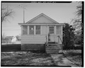 | 5,560 × 4,468 (23.69 MB) | Fæ (talk | contribs) | GWToolset: Creating mediafile for Fæ. HABS 2014-08-04 3801-4000 |
You cannot overwrite this file.
File usage on Commons
The following page uses this file: