File:GENERAL VIEW FROM SOUTHWEST - Cannelton Cotton Mill, Superintendent's House, Front and Washington Streets, Cannelton, Perry County, IN HAER IND,62-CANN,2A-1.tif

Size of this JPG preview of this TIF file: 800 × 578 pixels. Other resolutions: 320 × 231 pixels | 640 × 462 pixels | 1,024 × 739 pixels | 1,280 × 924 pixels | 2,560 × 1,848 pixels | 5,353 × 3,865 pixels.
Original file (5,353 × 3,865 pixels, file size: 19.73 MB, MIME type: image/tiff)
Captions
Captions
Add a one-line explanation of what this file represents
| GENERAL VIEW FROM SOUTHWEST - Cannelton Cotton Mill, Superintendent's House, Front and Washington Streets, Cannelton, Perry County, IN | ||||
|---|---|---|---|---|
| Title |
GENERAL VIEW FROM SOUTHWEST - Cannelton Cotton Mill, Superintendent's House, Front and Washington Streets, Cannelton, Perry County, IN |
|||
| Description |
Boucher, Jack E |
|||
| Depicted place | Indiana; Perry County; Cannelton | |||
| Date | Documentation compiled after 1968 | |||
| Dimensions | 5 x 7 in. | |||
| Current location |
Library of Congress Prints and Photographs Division Washington, D.C. 20540 USA http://hdl.loc.gov/loc.pnp/pp.print |
|||
| Accession number |
HAER IND,62-CANN,2A-1 |
|||
| Credit line |
|
|||
| Notes |
|
|||
| References |
|
|||
| Source | https://www.loc.gov/pictures/item/in0106.photos.065629p | |||
| Permission (Reusing this file) |
|
|||

| Camera location | | View this and other nearby images on: OpenStreetMap |
|---|
File history
Click on a date/time to view the file as it appeared at that time.
| Date/Time | Thumbnail | Dimensions | User | Comment | |
|---|---|---|---|---|---|
| current | 02:36, 18 July 2014 | 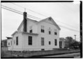 | 5,353 × 3,865 (19.73 MB) | Fæ (talk | contribs) | GWToolset: Creating mediafile for Fæ. HABS 16 July 2014 (1201:1400) |
You cannot overwrite this file.
File usage on Commons
The following page uses this file: