File:GMT France 2.pdf

Size of this JPG preview of this PDF file: 651 × 599 pixels. Other resolutions: 261 × 240 pixels | 521 × 480 pixels | 834 × 768 pixels | 1,112 × 1,024 pixels | 1,283 × 1,181 pixels.
Original file (1,283 × 1,181 pixels, file size: 433 KB, MIME type: application/pdf)
Captions
Captions
Add a one-line explanation of what this file represents
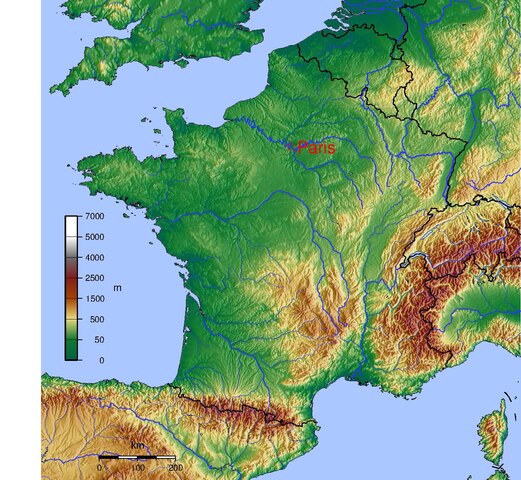
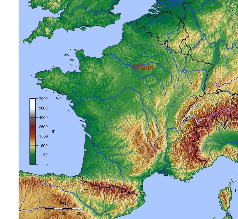
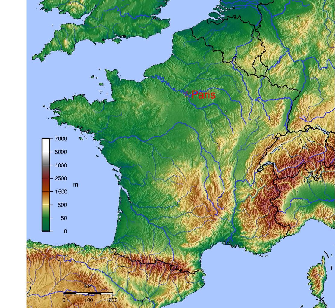
Map of France made with GMT and GTOPO30
| I, the copyright holder of this work, release this work into the public domain. This applies worldwide. In some countries this may not be legally possible; if so: I grant anyone the right to use this work for any purpose, without any conditions, unless such conditions are required by law. |
RFLAG="-R-6/10/41/52"
IFLAG=-I30c
GTOPO30=../GTOPO30

dem2ascii $RFLAG $GTOPO30/W020N90 $GTOPO30/W020N40 | surface -GFrance.grd $RFLAG $IFLAG -H0 -S50k -T0.4 -Z1.2
#!/bin/sh
RFLAG="-R-6/10/41/52"
FORMAT=-P
PROJECTION="$RFLAG -JM20 $FORMAT"
CITY_LAT=48.866667
CITY_LONG=2.333333
CITY_NAME=Paris

PALETTE=mountains2.cpt

PSFILE=france.ps
PNGFILE=france.png

grdgradient France.grd -Ne.5 -A100 -M -GFrance_i5.grd
grdimage -Ei -IFrance_i5.grd -C$PALETTE $PROJECTION France.grd -K > $PSFILE

RIVERS="\
  -I1/0.5p/50/50/255\
  -I2/0.4p/50/50/255\
  -I3/0.3p/50/50/255\
  -I4/0.2p/50/50/255\
  -I5/0.4p,-/50/50/255\
  -I6/0.3p,-/50/50/255\
  -I7/0.2p,-/50/50/255\
  -I8/1p/50/50/255"

SCALE=-Lfx4/1/45/200k

pscoast $PROJECTION\
  -Dh \
  -W0.5p/100/100/200 \
  -N1/0.75p \
  -S170/200/255\
  $BORDER\
  $SCALE\
  $RIVERS\
  -K -O\
  >> $PSFILE

#grdcontour -Csea.contour $PROJECTION -K -O France.grd >> $PSFILE

psscale -D1/8/6/0.5 -C$PALETTE -B:m: -L -K -O $FORMAT >>$PSFILE

echo "$CITY_LONG $CITY_LAT" | \
  psxy $PROJECTION -W255/0/0 -Sa0.5 -K -O >>$PSFILE

echo "$CITY_LONG $CITY_LAT 20 0 0 LM $CITY_NAME" | \
  pstext $PROJECTION -D0.25/0 -G255/0/0 -O >>$PSFILE

pstopnm -portrait -xsize=2000 -xborder=0 -yborder=0 -stdout -ppm  $PSFILE | pnmtopng > $PNGFILE
epstopdf $PSFILE
with:
# File mountains.cpt
#COLOR_MODEL = RGB
#
0       0       97      71      50      16      122     47
50      16      122     47      500     232     215     125
500     232     215     125     1500    161     67      0
1500    161     67      0       2500    130     30      30
2500    130     30      30      4000    110     110     110
4000    110     110     110     5000    255     255     255
5000    255     255     255     7000    255     255     255
N 0 97 71
F 255 0 0
B 0 97 71
Use gmtset to set font sizes.
File history
Click on a date/time to view the file as it appeared at that time.
| Date/Time | Thumbnail | Dimensions | User | Comment | |
|---|---|---|---|---|---|
| current | 09:52, 25 May 2005 |  | 1,283 × 1,181 (433 KB) | David.Monniaux (talk | contribs) | Map of France made with GMT and GTOPO30 {{PD}} |
You cannot overwrite this file.
File usage on Commons
There are no pages that use this file.