File:GOES-16 Cloud Products (34531695953).png

Size of this preview: 722 × 600 pixels. Other resolutions: 289 × 240 pixels | 578 × 480 pixels | 924 × 768 pixels | 1,233 × 1,024 pixels | 1,354 × 1,125 pixels.
Original file (1,354 × 1,125 pixels, file size: 1.61 MB, MIME type: image/png)
Captions
Captions
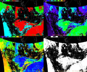
This example of GOES-16 derived products shows the cloud top phase, height, pressure and mask products applied to Advanced Baseline Imager imagery of the full disk on June 2, 2017.
Summary edit
.png&action=edit§ion=1)
| Description |
English: This example of GOES-16 derived products shows the cloud top phase, height, pressure and mask products applied to Advanced Baseline Imager imagery of the full disk on June 2, 2017. Cloud top phase enables meteorologists to better monitor and track changes in the water properties of clouds, improve icing forecasts for the aviation community, and aid in improving warnings for severe weather. Cloud top height information is used to forecast convective development and pressure information is crucial for the generation of satellite-derived winds. Clear sky mask produces a cloud classification for each pixel: cloudy, probably cloudy, clear, or probably clear. These products are useful for weather forecasting and improving aviation safety.
Note: This is preliminary, non-operational data as GOES-16 undergoes on-orbit testing. The data products shown are in beta maturity status, which means the product is made available to users to gain familiarity with data formats and parameters. The product has been minimally validated and may still contain errors and is not optimized for operational use. Credit: CIMSS View more GOES-16 data and imagery at www.goes-r.gov/multimedia/goes-16DataAndImagery.html |
| Date | Taken on 16 June 2017, 09:00:17 |
| Source | GOES-16 Cloud Products |
| Author | NOAASatellites |
| Flickr set | GOES-16 Preliminary Data and Imagery |
| Flickr tags | goesr; cloudtoppressure; nesdis; noaasatelliteandinformationservice; satelliteimagery; noaa; cloudtopphase; goes16; noaasatellites; derivedproducts; goesrseries; cloudtopheight; clearskymask |
Licensing edit
.png&action=edit§ion=2)
| This image was originally posted to Flickr by NOAASatellites at https://flickr.com/photos/125201706@N06/34531695953. It was reviewed on 21 February 2024 by FlickreviewR 2 and was confirmed to be licensed under the terms of the Public Domain Mark. |
This image is in the public domain because it contains materials that originally came from the U.S. National Oceanic and Atmospheric Administration, taken or made as part of an employee's official duties.
|
File history
Click on a date/time to view the file as it appeared at that time.
| Date/Time | Thumbnail | Dimensions | User | Comment | |
|---|---|---|---|---|---|
| current | 22:50, 21 February 2024 | | 1,354 × 1,125 (1.61 MB) | OptimusPrimeBot (talk | contribs) | #Spacemedia - Upload of https://live.staticflickr.com/4266/34531695953_2e39730004_o.png via Commons:Spacemedia |
You cannot overwrite this file.
File usage on Commons
There are no pages that use this file.
.png&oldid=854339574)