File:GZMetro-2-EN-Antilovsky.svg

Size of this PNG preview of this SVG file: 512 × 488 pixels. Other resolutions: 252 × 240 pixels | 504 × 480 pixels | 806 × 768 pixels | 1,074 × 1,024 pixels | 2,149 × 2,048 pixels.
Original file (SVG file, nominally 512 × 488 pixels, file size: 2.66 MB)
Captions
Captions
Add a one-line explanation of what this file represents
Summary edit
| Description |
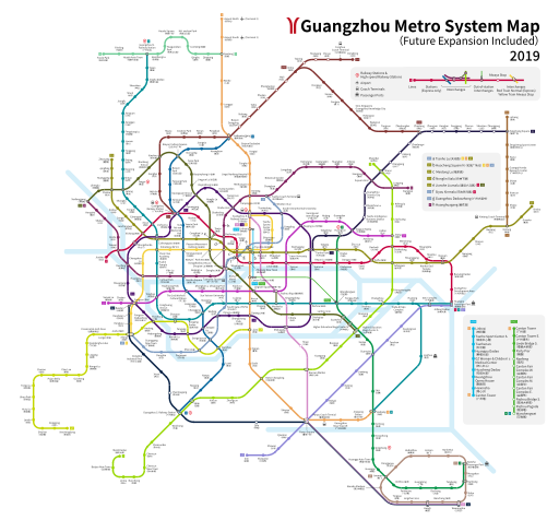
English: Guangzhou Metro System Map 2019, future extension Included, English. This map is outdated, please refer to the Bilingual version or the information on Wikipedia. |
| Date | |
| Source | Own work |
| Author | Antilovsky |
| Other versions |
|
Licensing edit
I, the copyright holder of this work, hereby publish it under the following license:
This file is licensed under the Creative Commons Attribution-Share Alike 4.0 International license.
- You are free:
- to share – to copy, distribute and transmit the work
- to remix – to adapt the work
- Under the following conditions:
- attribution – You must give appropriate credit, provide a link to the license, and indicate if changes were made. You may do so in any reasonable manner, but not in any way that suggests the licensor endorses you or your use.
- share alike – If you remix, transform, or build upon the material, you must distribute your contributions under the same or compatible license as the original.
File history
Click on a date/time to view the file as it appeared at that time.
| Date/Time | Thumbnail | Dimensions | User | Comment | |
|---|---|---|---|---|---|
| current | 12:14, 4 January 2019 | | 512 × 488 (2.66 MB) | Antilovsky (talk | contribs) | 调整底色 |
| 11:47, 4 January 2019 |  | 512 × 488 (2.66 MB) | Antilovsky (talk | contribs) | 调整拓扑结构,修正错误 | |
| 20:48, 1 January 2019 |  | 512 × 458 (2.65 MB) | Antilovsky (talk | contribs) | Renews, Corrections. Added Chinese Names | |
| 20:42, 29 December 2018 |  | 512 × 458 (1.65 MB) | Antilovsky (talk | contribs) | 修正错误 | |
| 17:41, 29 December 2018 |  | 512 × 458 (1.65 MB) | Antilovsky (talk | contribs) | 修正错误 | |
| 23:17, 28 December 2018 |  | 512 × 458 (1.65 MB) | Antilovsky (talk | contribs) | 更新信息,修正錯誤 | |
| 00:10, 16 August 2018 |  | 1,420 × 1,271 (2.73 MB) | Antilovsky (talk | contribs) | Corrections for labels | |
| 09:48, 8 August 2018 |  | 1,420 × 1,271 (2.3 MB) | Antilovsky (talk | contribs) | Corrections | |
| 01:11, 7 August 2018 |  | 1,420 × 1,271 (2.3 MB) | Antilovsky (talk | contribs) | User created page with UploadWizard |
You cannot overwrite this file.
File usage on Commons
The following 9 pages use this file:
- User:Antilovsky
- User:Chumwa/OgreBot/Potential transport maps/2018 December 21-31
- User:Chumwa/OgreBot/Potential transport maps/2019 January 1-10
- User:Chumwa/OgreBot/Public transport information/2018 December 21-31
- User:Chumwa/OgreBot/Public transport information/2019 January 1-10
- User:Chumwa/OgreBot/Transport Maps/2018 December 21-31
- User:Chumwa/OgreBot/Transport Maps/2019 January 1-10
- User:Chumwa/OgreBot/Travel and communication maps/2018 December 21-31
- User:Chumwa/OgreBot/Travel and communication maps/2019 January 1-10
File usage on other wikis
The following other wikis use this file:
- Usage on en.wikipedia.org