File:Ganzepoot Nieuport.png

Size of this preview: 600 × 599 pixels. Other resolutions: 240 × 240 pixels | 626 × 625 pixels.
Original file (626 × 625 pixels, file size: 400 KB, MIME type: image/png)
Captions
Captions
Add a one-line explanation of what this file represents
Summary edit
| Description |
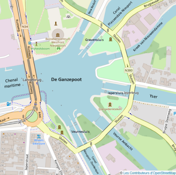
Français : Cette image représente une carte du complexe d'écluses De Ganzepoot (ou Patte d'oie) situé à Nieuport, à partir duquel la plaine de l'Yser fut inondée durant la Première Guerre mondiale.
On y voit les 6 voies hydrauliques aboutissant à ce complexe, et les ouvrages d'art qui l'équipent (dont les 3 écluses à sas). Cette image permet de visualiser la forme en "patte d'oie" du complexe d'écluses. Elle est constituée d'un détail de carte OpenStreetMap auquel on été ajoutés les noms des voies hydrauliques et des écluses. |
| Date | |
| Source | Own work |
| Author | Duvivier.Michel |
Licensing edit
I, the copyright holder of this work, hereby publish it under the following license:
| This file is made available under the Creative Commons CC0 1.0 Universal Public Domain Dedication. | |
| The person who associated a work with this deed has dedicated the work to the public domain by waiving all of their rights to the work worldwide under copyright law, including all related and neighboring rights, to the extent allowed by law. You can copy, modify, distribute and perform the work, even for commercial purposes, all without asking permission.
|
File history
Click on a date/time to view the file as it appeared at that time.
| Date/Time | Thumbnail | Dimensions | User | Comment | |
|---|---|---|---|---|---|
| current | 10:34, 25 April 2024 | | 626 × 625 (400 KB) | Duvivier.Michel (talk | contribs) | Remplacer "Ganzepoot" par "De Ganzepoot" |
| 11:25, 24 March 2024 |  | 626 × 625 (398 KB) | Duvivier.Michel (talk | contribs) | Uploaded own work with UploadWizard |
You cannot overwrite this file.
File usage on Commons
There are no pages that use this file.
File usage on other wikis
The following other wikis use this file:
- Usage on fr.wikipedia.org