File:Gardiner Expressway 0831.JPG

Size of this preview: 400 × 600 pixels. Other resolutions: 160 × 240 pixels | 320 × 480 pixels | 512 × 768 pixels | 682 × 1,024 pixels | 1,365 × 2,048 pixels | 2,848 × 4,272 pixels.
Original file (2,848 × 4,272 pixels, file size: 3.41 MB, MIME type: image/jpeg)
Captions
Captions
Add a one-line explanation of what this file represents
Summary edit
| Description |
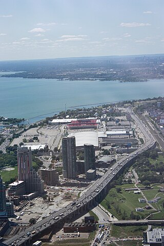
English: The Gardiner Expressway, looking west from the CN Tower, with Fort York in the right foreground and the CNE and BMO Field toward the upper left and Ontario Place to the extreme left. |
| Date | |
| Source | Own work |
| Author | Rrburke |
| Camera location | | View this and other nearby images on: OpenStreetMap |
|---|
Licensing edit
I, the copyright holder of this work, hereby publish it under the following license:
This file is licensed under the Creative Commons Attribution-Share Alike 3.0 Unported license.
- You are free:
- to share – to copy, distribute and transmit the work
- to remix – to adapt the work
- Under the following conditions:
- attribution – You must give appropriate credit, provide a link to the license, and indicate if changes were made. You may do so in any reasonable manner, but not in any way that suggests the licensor endorses you or your use.
- share alike – If you remix, transform, or build upon the material, you must distribute your contributions under the same or compatible license as the original.
File history
Click on a date/time to view the file as it appeared at that time.
| Date/Time | Thumbnail | Dimensions | User | Comment | |
|---|---|---|---|---|---|
| current | 14:17, 8 August 2009 | | 2,848 × 4,272 (3.41 MB) | Rrburke (talk | contribs) | Corrected rotation |
| 23:57, 7 August 2009 |  | 4,272 × 2,848 (4.19 MB) | Rrburke (talk | contribs) | {{Information |Description={{en|1=The Gardiner Expressway, looking west from the CN Tower, with Fort York in the right foreground and the CNE and BMO Field toward |
You cannot overwrite this file.
File usage on Commons
The following page uses this file:
File usage on other wikis
The following other wikis use this file:
- Usage on zh.wikipedia.org