File:Gem-Papendrecht-OpenTopo.jpg

Size of this preview: 800 × 564 pixels. Other resolutions: 320 × 226 pixels | 640 × 451 pixels | 1,024 × 722 pixels | 1,280 × 902 pixels | 2,216 × 1,562 pixels.
Original file (2,216 × 1,562 pixels, file size: 611 KB, MIME type: image/jpeg)
Captions
Captions
Add a one-line explanation of what this file represents

Summary edit
| Description |
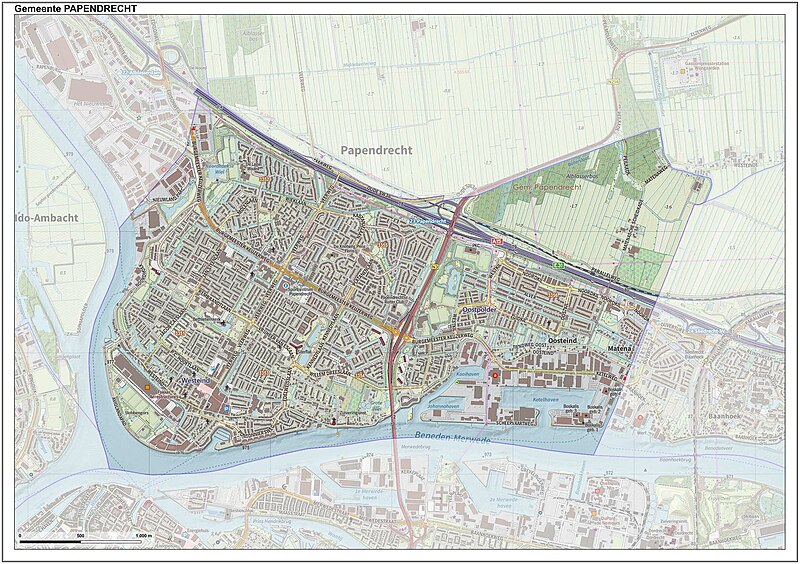
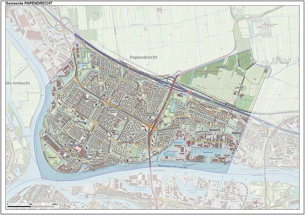
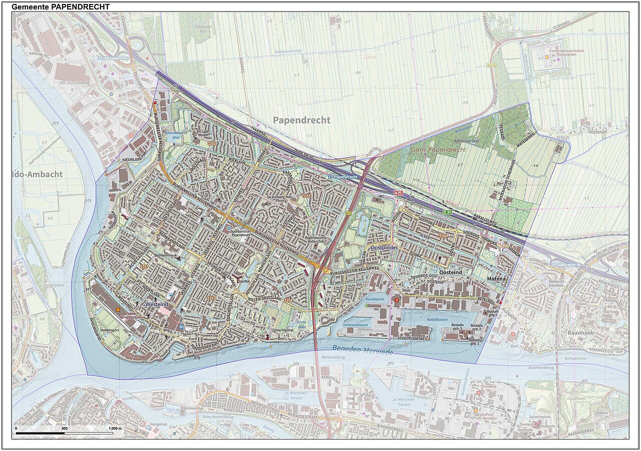
Nederlands: Topografische gemeentekaart. Resolutie: 400 pixels/km.
Kaartbeeld samengesteld uit de open geodata van de Top10NL en Top25namen (Kadaster), Creative Commons-BY licentie. Gebouwvlakken uit open geodata BAG extract. Wegen uit de OpenStreetMap, OpenStreetMap community. Reliëfschaduw uit de Actuele Hoogtekaart AHN2. Samenstelling en kleurenschema: Jan-Willem van Aalst, met QGIS. Zie ook de Legenda. |
| Date | |
| Source | Own work |
| Author | Janwillemvanaalst |
Licensing edit
I, the copyright holder of this work, hereby publish it under the following license:
This file is licensed under the Creative Commons Attribution-Share Alike 4.0 International license.
- You are free:
- to share – to copy, distribute and transmit the work
- to remix – to adapt the work
- Under the following conditions:
- attribution – You must give appropriate credit, provide a link to the license, and indicate if changes were made. You may do so in any reasonable manner, but not in any way that suggests the licensor endorses you or your use.
- share alike – If you remix, transform, or build upon the material, you must distribute your contributions under the same or compatible license as the original.
File history
Click on a date/time to view the file as it appeared at that time.
| Date/Time | Thumbnail | Dimensions | User | Comment | |
|---|---|---|---|---|---|
| current | 13:16, 9 July 2023 | | 2,216 × 1,562 (611 KB) | Janwillemvanaalst (talk | contribs) | Map layers update, July 2023 |
| 13:09, 17 September 2022 |  | 2,638 × 1,859 (1.05 MB) | Janwillemvanaalst (talk | contribs) | map layers update, September 2022 | |
| 12:35, 6 January 2022 |  | 2,638 × 1,859 (1.05 MB) | Janwillemvanaalst (talk | contribs) | Map layers update, 1 Jan. 2022 | |
| 22:14, 8 March 2021 |  | 2,638 × 1,859 (1.02 MB) | Janwillemvanaalst (talk | contribs) | Map layers update, Feb. 2021 | |
| 22:07, 6 March 2020 |  | 2,645 × 1,867 (1.04 MB) | Janwillemvanaalst (talk | contribs) | Map layers update, February 2020 | |
| 19:04, 25 May 2017 |  | 2,844 × 2,034 (3.41 MB) | Janwillemvanaalst (talk | contribs) | Map layers update, April 2017 | |
| 11:45, 25 December 2016 |  | 2,844 × 2,034 (3.56 MB) | Janwillemvanaalst (talk | contribs) | Map layers update, Dec. 2016 | |
| 16:57, 31 December 2015 |  | 2,844 × 2,034 (3.78 MB) | Janwillemvanaalst (talk | contribs) | Map Layers update, Dec.2015 | |
| 14:46, 19 July 2015 |  | 2,846 × 2,036 (2.81 MB) | Janwillemvanaalst (talk | contribs) | Map layers update, June 2015 | |
| 13:28, 15 March 2015 |  | 2,844 × 2,034 (2.19 MB) | Janwillemvanaalst (talk | contribs) | Map layers update, March 2015 |
You cannot overwrite this file.
File usage on Commons
There are no pages that use this file.
File usage on other wikis
The following other wikis use this file:
- Usage on af.wikipedia.org
- Usage on ar.wikipedia.org
- Usage on en.wikipedia.org
- Usage on fy.wikipedia.org
- Usage on nl.wikipedia.org
- Usage on sl.wikipedia.org
- Usage on zea.wikipedia.org
- Usage on zh.wikipedia.org