File:Generalʹnai︠a︡ Karta Permskoĭ Gubernii Sʺ pokazaniemʺ pochtovykhʺ i bolʹshikhʺ proi︠e︡zzhikhʺ dorogʺ, stant︠s︡iĭ i razstoi︠a︡nii︠a︡ mezhdu onymi verstʺ. LOC 2018688684.tif

Size of this JPG preview of this TIF file: 710 × 600 pixels. Other resolutions: 284 × 240 pixels | 568 × 480 pixels | 909 × 768 pixels | 1,212 × 1,024 pixels | 2,425 × 2,048 pixels | 5,792 × 4,892 pixels.
Original file (5,792 × 4,892 pixels, file size: 81.07 MB, MIME type: image/tiff)
Captions
Captions
Add a one-line explanation of what this file represents
Summary
edit| Description |
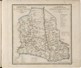
English: This 1824 map of Perm Provinceis from a larger work,Geograficheskii atlas Rossiiskoi imperii, tsarstva Pol'skogo i velikogo kniazhestva Finliandskogo(Geographical atlas of the Russian Empire, the Kingdom of Poland, and the Grand Duchy of Finland), containing 60 maps of the Russian Empire. Compiled and engraved by Colonel V.P. Piadyshev, it reflects the detailed mapping carried out by Russian military cartographers in the first quarter of the 19th century. The map shows population centers (six gradations by size), postal stations, roads (four types),provincial and district borders,monasteries, and factories. Distances are shown in versts, a Russian measure, now no longer used, equal to 1.07 kilometers. Legends and place-names are in Russian and French. Perm owes its existence to Tsar Peter the Great, who founded the city as a center of industrial activity in the Ural Mountains in the early 18th century. The Perm region subsequently was home to numerous metallurgical, paper, chemical, and munitions factories over the years. The city of Ekaterinburg became an important administrative center in the tsarist era, astride the geographical border between Europe and Asia. World Digital Library. |
||
| Title | Generalʹnai︠a︡ Karta Permskoĭ Gubernii Sʺ pokazaniemʺ pochtovykhʺ i bolʹshikhʺ proi︠e︡zzhikhʺ dorogʺ, stant︠s︡iĭ i razstoi︠a︡nii︠a︡ mezhdu onymi verstʺ. | ||
| Shelf ID | http://lccn.loc.gov/2018688684 | ||
| Date | |||
| Source | https://www.loc.gov/item/2018688684/ | ||
| Author | Pi︠A︡Dyshev, Vasiliĭ Petrovich; Ieremin; Russia. General Staff. Military Topographical Depot | ||
| Permission (Reusing this file) |
|
||
| Other versions |
|
||
| Location | Russian Federation · Perm Krai | ||
| Part of | Geographical Atlas Of The Russian Empire, The Kingdom Of Poland, And The Grand Duchy Of Finland · Catalog · National Library Of Russia · Meeting Of Frontiers | ||
| Subject | Russian Federation · Maps · Atlases · Siberia · Perm Krai |


Licensing
edit|
This is a faithful photographic reproduction of a two-dimensional, public domain work of art. The work of art itself is in the public domain for the following reason:
The official position taken by the Wikimedia Foundation is that "faithful reproductions of two-dimensional public domain works of art are public domain".
This photographic reproduction is therefore also considered to be in the public domain in the United States. In other jurisdictions, re-use of this content may be restricted; see Reuse of PD-Art photographs for details. | ||||
File history
Click on a date/time to view the file as it appeared at that time.
| Date/Time | Thumbnail | Dimensions | User | Comment | |
|---|---|---|---|---|---|
| current | 01:49, 21 January 2020 |  | 5,792 × 4,892 (81.07 MB) | Fæ (talk | contribs) | LOC Maps https://www.loc.gov/item/2018688684/ #21002 |
You cannot overwrite this file.
File usage on Commons
The following page uses this file: