File:General map of the borough of Richmond (Staten Island) in the city of New York - showing in addition to the existing topographical features of the borough a tentative and preliminary plan for a street NYPL1689258.tiff

Size of this JPG preview of this TIF file: 799 × 600 pixels. Other resolutions: 320 × 240 pixels | 640 × 480 pixels | 1,023 × 768 pixels | 1,280 × 961 pixels | 2,560 × 1,922 pixels | 7,230 × 5,428 pixels.
Original file (7,230 × 5,428 pixels, file size: 112.28 MB, MIME type: image/tiff)
Captions
Captions
Add a one-line explanation of what this file represents
Summary
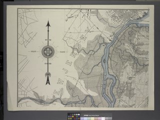
edit| Description | General map of the borough of Richmond (Staten Island) in the city of New York : showing in addition to the existing topographical features of the borough a tentative and preliminary plan for a street system of the same.; Maps of New York City and State / New York City / Staten Island | |||||||||||||||||||||||
| Notes | Relief shown by contours. | |||||||||||||||||||||||
| Item physical description | 1 map on 12 sheets : col. ; 253 x 255 cm., sheets 68 x 98 cm. | |||||||||||||||||||||||
| Catalogue call number | Map Div. (Staten Island, New York. 1901) (General map of the borough of Richmond (Staten Island)) | |||||||||||||||||||||||
| Date | ||||||||||||||||||||||||
| Source |
http://digitalgallery.nypl.org/nypldigital/dgkeysearchdetail.cfm?imageID=1689266
|
|||||||||||||||||||||||
| Author | New York (N.Y.). Topographical Bureau -- Author | |||||||||||||||||||||||
| Permission (Reusing this file) |
From The Lionel Pincus and Princess Firyal Map Division. http://maps.nypl.org
|
|||||||||||||||||||||||
| Location | Stephen A. Schwarzman Building / The Lionel Pincus and Princess Firyal Map Division | |||||||||||||||||||||||
| Digital item published | 12-1-2008; updated 4-5-2012 | |||||||||||||||||||||||
| Digital ID | 1689258 | |||||||||||||||||||||||

The making of this file was supported by Wikimedia UK.
To see other files made with the support of Wikimedia UK, please see the category Supported by Wikimedia UK.
|
File history
Click on a date/time to view the file as it appeared at that time.
| Date/Time | Thumbnail | Dimensions | User | Comment | |
|---|---|---|---|---|---|
| current | 16:17, 28 April 2014 |  | 7,230 × 5,428 (112.28 MB) | Fæ (talk | contribs) | GWToolset:: Creating mediafile for Fæ. Tranche 3 5495-7474 (2) |
You cannot overwrite this file.
File usage on Commons
There are no pages that use this file.